IMAGES TAKEN NEAR TO
Pembroke Close, KIRKBY STEPHEN, CA17 4BF
Introduction
This page details the photographs taken nearby to Pembroke Close, CA17 4BF by members of the Geograph project.
The Geograph project started in 2005 with the aim of publishing, organising and preserving representative images for every square kilometre of Great Britain, Ireland and the Isle of Man.

There are currently over 7.5m images from over14,400 individuals and you can help contribute to the project by visiting https://www.geograph.org.uk
Image Map
Images are licensed for reuse under creativecommons.org/licenses/by-sa/2.0
Notes
- Clicking on the map will re-center to the selected point.
- The higher the marker number, the further away the image location is from the centre of the postcode.
Image Listing (149 Images Found)
Images are licensed for reuse under creativecommons.org/licenses/by-sa/2.0
Image
Details
Distance
1
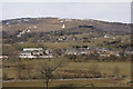
Brough from the castle
Warcop Fell in the background.
Image: © Mike Pennington
Taken: 1 Apr 2013
0.05 miles
3
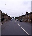
Market Brough, High Street
Once upon a time before the A66 by-pass was built, Brough was a busy village that thrived due to its situation on the high road from the west of Scotland to the A1 at Scotch Corner.
Nowadays its once hectic transport cafe is a business centre and the pictured High Street is as quiet as a picturesque Pennine village should be.
Image: © Robert Murray
Taken: 15 Oct 2010
0.11 miles
4
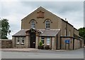
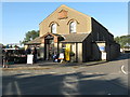
Brough Memorial Hall
Dated 1924 and functional rather than pretty.
Image: © Gordon Hatton
Taken: 11 Jul 2020
0.11 miles
5
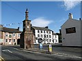
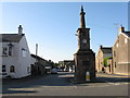
Brough, Cumbria: The Coronation clock tower
Image: © Martyn Gorman
Taken: 21 Sep 2006
0.11 miles
6
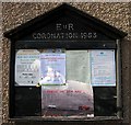
Village notice board, Brough
Erected in 1953, the year in which Elizabeth II was crowned.
Image: © Martyn Gorman
Taken: 21 Sep 2006
0.11 miles
7
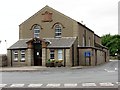
Brough Farmers' Market
Held in the Memorial Hall on the third Saturday of each month.
Image: © M J Richardson
Taken: 15 Oct 2011
0.11 miles
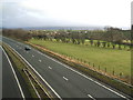
9
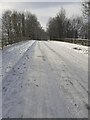
Bridge over A66 at Brough
Snow covered bridge on Musgrave Lane
Image: © colin
Taken: 29 Nov 2021
0.12 miles
10
New Street, Brough
The B6276 heading southwards towards the A66 junction and Kirkby Stephen, with the memorial clock tower in the foreground and the castle just visible in the distance.
Image: © M J Richardson
Taken: 15 Oct 2011
0.12 miles