IMAGES TAKEN NEAR TO
The Crescent, KIRKBY STEPHEN, CA17 4AH
Introduction
This page details the photographs taken nearby to The Crescent, CA17 4AH by members of the Geograph project.
The Geograph project started in 2005 with the aim of publishing, organising and preserving representative images for every square kilometre of Great Britain, Ireland and the Isle of Man.

There are currently over 7.5m images from over14,400 individuals and you can help contribute to the project by visiting https://www.geograph.org.uk
Image Map
Images are licensed for reuse under creativecommons.org/licenses/by-sa/2.0
Notes
- Clicking on the map will re-center to the selected point.
- The higher the marker number, the further away the image location is from the centre of the postcode.
Image Listing (153 Images Found)
Images are licensed for reuse under creativecommons.org/licenses/by-sa/2.0
Image
Details
Distance
1
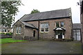
Kirkby Stephen Primary School
There is an Ordnance Survey benchmark Image on the right hand side of the school at its front corner, beside the black post of metal gates
Image: © Roger Templeman
Taken: 5 Sep 2017
0.07 miles
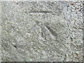
2
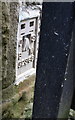
Benchmark on Kirkby Stephen Primary School
Ordnance Survey flush bracket (serial identifier G2368) benchmark described on the Bench Mark Database at www.bench-marks.org.uk/bm14455
Image: © Roger Templeman
Taken: 5 Sep 2017
0.09 miles
3
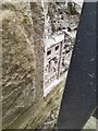
Ordnance Survey Flush Bracket (G2368)
This OS Flush Bracket can be found on the NW angle of the school. It marks a point 175.669m above mean sea level.
Image: © Adrian Dust
Taken: 28 Oct 2023
0.09 miles

5
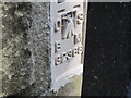
Ordnance Survey Flush Bracket G2368
This bracket can be found on the wall of the school on Nateby Road.
For more detail see : http://www.bench-marks.org.uk/bm14455
Image: © Peter Wood
Taken: 4 Jun 2012
0.09 miles
6
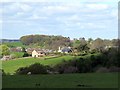
Houses south of Kirkby Stephen
The crenellated tower of Stobars Hall Image can be seen in the trees behind.
Image: © Andrew Curtis
Taken: 22 Apr 2017
0.09 miles
7
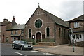
Upper Eden Baptist Church, Kirkby Stephen
Image: © Alexander P Kapp
Taken: 4 Oct 2005
0.10 miles
8
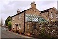
Bollam Cottage, Nateby Road
There is an OS benchmark Image on the road face of the house at its far corner
Image: © Luke Shaw
Taken: 16 Feb 2020
0.10 miles
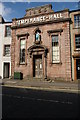
10
Ordnance Survey Cut Mark
This mark can be found on the wall of a building in Mellbecks.
For more detail see : http://www.bench-marks.org.uk/bm24368
Image: © Peter Wood
Taken: 4 Jun 2012
0.11 miles