IMAGES TAKEN NEAR TO
St. Michaels Lane, APPLEBY-IN-WESTMORLAND, CA16 6UH
Introduction
This page details the photographs taken nearby to St. Michaels Lane, CA16 6UH by members of the Geograph project.
The Geograph project started in 2005 with the aim of publishing, organising and preserving representative images for every square kilometre of Great Britain, Ireland and the Isle of Man.

There are currently over 7.5m images from over14,400 individuals and you can help contribute to the project by visiting https://www.geograph.org.uk
Image Map
Images are licensed for reuse under creativecommons.org/licenses/by-sa/2.0
Notes
- Clicking on the map will re-center to the selected point.
- The higher the marker number, the further away the image location is from the centre of the postcode.
Image Listing (75 Images Found)
Images are licensed for reuse under creativecommons.org/licenses/by-sa/2.0
Image
Details
Distance
1
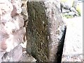
Old Milestone by the B6542, Bongate, South Appleby
Carved stone post by the B6542 (was A66), in parish of APPLEBY IN WESTMORLAND (EDEN District), South Appleby, Bongate, by No.7, in pavement, behind metal milepost, on Northeast side of road. Old Appleby stone, erected by the Brough & Eamont Bridge turnpike trust in the 19th century.
Behind listed milepost: WE_BGAP08M Image
Inscription reads:-
: To / Brough / VIII / Miles : : To / (Penrith) / XIII :
Milestone Society National ID: WE_BGAP08S.
Image: © C Smith / G Farrington
Taken: 18 Sep 2007
0.05 miles
2
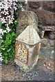
Old Milepost by the B6542, Bongate, Appleby-in-Westmorland
Metal post with attached metal plate by the B6542 (was A66), in parish of Appleby-in-Westmorland (EDEN District), South Appleby, Bongate, by No.7, by wall of Brunswick House, on East side of road. Appleby post, erected by the Brough & Eamont Bridge turnpike trust in the 19th century.
In front of Milestone: WE_BGAP08S Image
Inscription reads:-
: BROUGH / 8 / MILES : : (PENRITH / 13 / MILES) :
Grade II listed.
List Entry Number: 1145597 https://historicengland.org.uk/listing/the-list/list-entry/1145597
Milestone Society National ID: WE_BGAP08M.
Image: © C Smith / G Farrington
Taken: 18 Sep 2007
0.05 miles
3
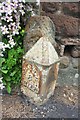
Old milestone, Bongate
8 miles to Brough
Image: © Roger Templeman
Taken: 26 May 2015
0.06 miles
5
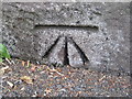
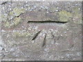
Ordnance Survey Cut Mark
This mark can be found at the entrance to Bongate House.
For more detail see : http://www.bench-marks.org.uk/bm24348
Image: © Peter Wood
Taken: 4 Jun 2012
0.07 miles
6
Benchmark on Bongate House
Ordnance Survey 1844 cut mark benchmark on wall at entrance to Bongate House. Further details of the mark can be found on the Bench Mark Database at http://www.bench-marks.org.uk/bm24348
Image: © Roger Templeman
Taken: 26 Jun 2010
0.07 miles
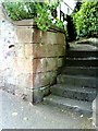
7
Bongate House, Bongate
There is an OS benchmark Image on the base of the wall left of the steps at the right hand side of the image
Image: © Roger Templeman
Taken: 26 May 2015
0.07 miles
8
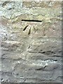
Benchmark on wall of Bongate
Ordnance Survey cut mark benchmark verified in 1970 on wall of Bongate, which was the A66, but is now the B6542. Further information about the mark may be found on the Bench Mark Database at http://www.bench-marks.org.uk/bm24349
Image: © Roger Templeman
Taken: 26 Jun 2010
0.10 miles
9
Ordnance Survey Cut Mark
This mark can be found on the roadside wall in Bongate.
For more detail see : http://www.bench-marks.org.uk/bm24349
Image: © Peter Wood
Taken: 4 Jun 2012
0.10 miles
10
Milestone, Bongate, Appleby
The metal part is said to be early 19C, and is Grade II listed. It has raised lettering "Brough 8 miles, Penrith 13 miles". However the stone on which it was fixed must have been earlier as it has the remains of 'Miles' carved on each face, the inscription above this having been removed when the stone was re-shaped.
Image: © Humphrey Bolton
Taken: 3 Nov 2006
0.10 miles