IMAGES TAKEN NEAR TO
Drybeck, APPLEBY-IN-WESTMORLAND, CA16 6TG
Introduction
This page details the photographs taken nearby to CA16 6TG by members of the Geograph project.
The Geograph project started in 2005 with the aim of publishing, organising and preserving representative images for every square kilometre of Great Britain, Ireland and the Isle of Man.

There are currently over 7.5m images from over14,400 individuals and you can help contribute to the project by visiting https://www.geograph.org.uk
Image Map
Images are licensed for reuse under creativecommons.org/licenses/by-sa/2.0
Notes
- Clicking on the map will re-center to the selected point.
- The higher the marker number, the further away the image location is from the centre of the postcode.
Image Listing (1 Images Found)
Images are licensed for reuse under creativecommons.org/licenses/by-sa/2.0
Image
Details
Distance
1
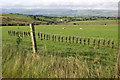
Graveyard for 32 Moles
It is not uncommon to come across dead moles strung up on farm fences when walking in the countryside. However 32 is definitely a record for me. Beyond the moles lie the valley of Dry Beck and the road to the village of the same name.
Image: © Peter Standing
Taken: 28 Jul 2007
0.16 miles