IMAGES TAKEN NEAR TO
Drybeck, APPLEBY-IN-WESTMORLAND, CA16 6TF
Introduction
This page details the photographs taken nearby to CA16 6TF by members of the Geograph project.
The Geograph project started in 2005 with the aim of publishing, organising and preserving representative images for every square kilometre of Great Britain, Ireland and the Isle of Man.

There are currently over 7.5m images from over14,400 individuals and you can help contribute to the project by visiting https://www.geograph.org.uk
Image Map
Images are licensed for reuse under creativecommons.org/licenses/by-sa/2.0
Notes
- Clicking on the map will re-center to the selected point.
- The higher the marker number, the further away the image location is from the centre of the postcode.
Image Listing (21 Images Found)
Images are licensed for reuse under creativecommons.org/licenses/by-sa/2.0
Image
Details
Distance
1
Plaque on bench, Drybeck
Fixed to Image to commemorate the coronation of Queen Elizabeth II. 'Hoff Parish' can just be made out above the plaque.
Image: © Karl and Ali
Taken: 21 Jun 2015
0.01 miles
2
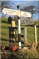
Old Direction Sign - Signpost by Bridge End Farm, Drybeck
Ball finial - 3 arms; Bowerbank Foundry by the UC road, in parish of Hoff (Eden District), Drybeck.
Surveyed
Milestone Society National ID: WE_NY6615
Image: © Milestone Society
Taken: Unknown
0.02 miles
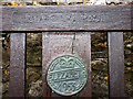
3
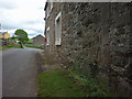
Cut benchmark, Drybeck
At an altitude of 186.416m asl.
Image: © Karl and Ali
Taken: 21 Jun 2015
0.02 miles