IMAGES TAKEN NEAR TO
Banks Terrace, APPLEBY-IN-WESTMORLAND, CA16 6QZ
Introduction
This page details the photographs taken nearby to Banks Terrace, CA16 6QZ by members of the Geograph project.
The Geograph project started in 2005 with the aim of publishing, organising and preserving representative images for every square kilometre of Great Britain, Ireland and the Isle of Man.

There are currently over 7.5m images from over14,400 individuals and you can help contribute to the project by visiting https://www.geograph.org.uk
Image Map
Images are licensed for reuse under creativecommons.org/licenses/by-sa/2.0
Notes
- Clicking on the map will re-center to the selected point.
- The higher the marker number, the further away the image location is from the centre of the postcode.
Image Listing (357 Images Found)
Images are licensed for reuse under creativecommons.org/licenses/by-sa/2.0
Image
Details
Distance
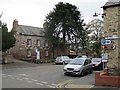
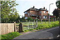
1
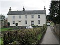
Banks Terrace, Appleby in Westmorland
The walkway on the right is known as Banks Lane. It climbs steeply high above the River Eden.
Image: © Andrew Curtis
Taken: 22 Oct 2010
0.00 miles
2
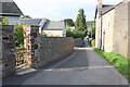
View north along Banks Lane
There is an OS benchmark Image at the base of the wall at the left hand edge of the image
Image: © Roger Templeman
Taken: 4 Sep 2014
0.01 miles
3
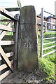
Benchmark on Banks Lane gatepost
Ordnance Survey cut mark benchmark described on the Bench Mark Database at http://www.bench-marks.org.uk/bm24354
Image: © Roger Templeman
Taken: 4 Sep 2014
0.01 miles
4
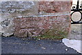
Benchmark on Banks Lane wall
Ordnance Survey cut mark benchmark described on the Bench Mark Database at http://www.bench-marks.org.uk/bm24353
Image: © Roger Templeman
Taken: 4 Sep 2014
0.03 miles
5
Holme Street, Appleby in Westmorland
The house on the far corner is known as The Armoury and dates from the early C18th. There is a low stone barn to its right. Both are listed buildings, grade II. The front is dominated by a large monkey puzzle tree.
http://www.heritagegateway.org.uk/Gateway/Results_Single.aspx?uid=73699&resourceID=5
Image: © Andrew Curtis
Taken: 22 Oct 2010
0.03 miles
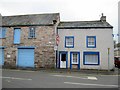
6
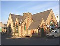
Converted school, Chapel Street, Appleby
This is a former school.
Image: © Humphrey Bolton
Taken: 3 Nov 2006
0.03 miles
8
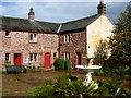
Hospital of St Anne, Appleby
This almshouse was founded in 1651. The buildings, grouped round a central court accessed through an arch, were altered and repaired in 1961.
Image: © Stephen McKay
Taken: 6 Oct 2006
0.03 miles
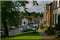
9
View along Banks Lane
There is an OS benchmark Image on the right hand gatepost of the gateway at the left hand side of the image
Image: © Roger Templeman
Taken: 4 Sep 2014
0.04 miles
10
Number 1, Doom Gate, Appleby in Westmorland
Doom Gate is an old street of Appleby and seems is made up of houses dating from 18th often with adjacent commercial buildings or agricultural barns.
http://www.heritagegateway.org.uk/Gateway/Results_Single.aspx?uid=73684&resourceID=5
Image: © Andrew Curtis
Taken: 22 Oct 2010
0.04 miles