IMAGES TAKEN NEAR TO
Warcop, APPLEBY-IN-WESTMORLAND, CA16 6PU
Introduction
This page details the photographs taken nearby to CA16 6PU by members of the Geograph project.
The Geograph project started in 2005 with the aim of publishing, organising and preserving representative images for every square kilometre of Great Britain, Ireland and the Isle of Man.

There are currently over 7.5m images from over14,400 individuals and you can help contribute to the project by visiting https://www.geograph.org.uk
Image Map
Images are licensed for reuse under creativecommons.org/licenses/by-sa/2.0
Notes
- Clicking on the map will re-center to the selected point.
- The higher the marker number, the further away the image location is from the centre of the postcode.
Image Listing (6 Images Found)
Images are licensed for reuse under creativecommons.org/licenses/by-sa/2.0
Image
Details
Distance

4

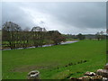
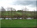
Squeeze stile at start of footpath running west along River Eden to Sandford Bridge
There is an Ordnance Survey benchmark Image on a stone at the right hand side of the squeeze stile.
Image: © Roger Templeman
Taken: 6 Aug 2024
0.24 miles

6
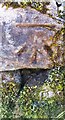
Benchmark on stone in wall on south side of road to Sandford near its east end
Ordnance Survey cut mark benchmark levelled at 140.269m above Newlyn Datum verified 1955
Image: © Roger Templeman
Taken: 6 Aug 2024
0.24 miles