IMAGES TAKEN NEAR TO
APPLEBY-IN-WESTMORLAND, CA16 6LH
Introduction
This page details the photographs taken nearby to CA16 6LH by members of the Geograph project.
The Geograph project started in 2005 with the aim of publishing, organising and preserving representative images for every square kilometre of Great Britain, Ireland and the Isle of Man.

There are currently over 7.5m images from over14,400 individuals and you can help contribute to the project by visiting https://www.geograph.org.uk
Image Map
Images are licensed for reuse under creativecommons.org/licenses/by-sa/2.0
Notes
- Clicking on the map will re-center to the selected point.
- The higher the marker number, the further away the image location is from the centre of the postcode.
Image Listing (7 Images Found)
Images are licensed for reuse under creativecommons.org/licenses/by-sa/2.0
Image
Details
Distance
1
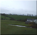
Lowfield Farm
High Cup Nick and Murton Pike can be seen behind.
Image: © Andrew Curtis
Taken: 28 May 2016
0.02 miles
2
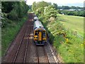
Sprinter heading south near Appleby
Northern Rail Class 158 DMU number 158861 on Settle to Carlisle railway.
Image: © Andrew Curtis
Taken: 28 May 2016
0.13 miles
4
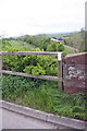
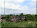
East end of parapet of bridge for B6542 over former railway
There is an OS benchmark Image near the left hand end of the parapet
Image: © Roger Templeman
Taken: 26 May 2015
0.14 miles
5
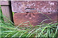
Benchmark on bridge over former Warcop - Appleby railway
Ordnance Survey cut mark benchmark described on the Bench Mark Database at http://www.bench-marks.org.uk/bm28301
Image: © Roger Templeman
Taken: 26 May 2015
0.15 miles
6
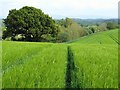
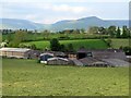
Bridleway across barley field at Causey Brow
Image: © Andrew Curtis
Taken: 28 May 2016
0.18 miles