IMAGES TAKEN NEAR TO
Flakebridge, APPLEBY-IN-WESTMORLAND, CA16 6JU
Introduction
This page details the photographs taken nearby to CA16 6JU by members of the Geograph project.
The Geograph project started in 2005 with the aim of publishing, organising and preserving representative images for every square kilometre of Great Britain, Ireland and the Isle of Man.

There are currently over 7.5m images from over14,400 individuals and you can help contribute to the project by visiting https://www.geograph.org.uk
Image Map
Images are licensed for reuse under creativecommons.org/licenses/by-sa/2.0
Notes
- Clicking on the map will re-center to the selected point.
- The higher the marker number, the further away the image location is from the centre of the postcode.
Image Listing (8 Images Found)
Images are licensed for reuse under creativecommons.org/licenses/by-sa/2.0
Image
Details
Distance
1
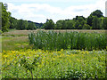
Marshy ground along the Frith Beck
Looking upstream from the Stock Bridge.
Image: © Oliver Dixon
Taken: 15 Jul 2015
0.12 miles
2

Dirt road north of Stock Bridge
The road leaving a minor road north of Stock Bridge close to the villages of Dufton and Brampton, heads towards the farm at Dufton Wood.
Image: © Trevor Littlewood
Taken: 11 Jun 2015
0.13 miles
3
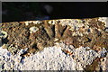
Arrow head cuts on top of NW parapet of Stock Bridge
Looks like part of an Ordnance Survey benchmark, but it probably isn't! There is an OS benchmark Image at the NE end of the parapet
Image: © Roger Templeman
Taken: 28 Jan 2019
0.16 miles
4

Benchmark at NE end of NW parapet of Stock Bridge
Ordnance Survey cut mark benchmark described on the Bench Mark Database at www.bench-marks.org.uk/bm105886
Image: © Roger Templeman
Taken: 19 Mar 2019
0.16 miles
5
Brampton Beck viewed over NW parapet of Stock Bridge
The significance of the carved arrowhead Image on the top of the centre of the parapet is unknown
Image: © Roger Templeman
Taken: 28 Jan 2019
0.17 miles
6

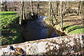
Marshy ground along the Frith Beck
Looking downstream from the Stock Bridge. Tuley tubes are protecting some young trees. The village of Brampton in the distance.
Image: © Oliver Dixon
Taken: 15 Jul 2015
0.18 miles
7
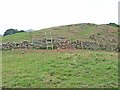
Ladder stile near Dufton Wood
Unusually, this stile is not on a public footpath, but its presence encouraged us to go the wrong way!
Image: © Oliver Dixon
Taken: 15 Aug 2006
0.25 miles
8

Benchmark on dry stone wall near road junction with track to Dufton Wood
Ordnance Survey cut mark benchmark described on the Bench Mark Database at www.bench-marks.org.uk/bm105869
Image: © Roger Templeman
Taken: 19 Mar 2019
0.25 miles