IMAGES TAKEN NEAR TO
APPLEBY-IN-WESTMORLAND, CA16 6JG
Introduction
This page details the photographs taken nearby to CA16 6JG by members of the Geograph project.
The Geograph project started in 2005 with the aim of publishing, organising and preserving representative images for every square kilometre of Great Britain, Ireland and the Isle of Man.

There are currently over 7.5m images from over14,400 individuals and you can help contribute to the project by visiting https://www.geograph.org.uk
Image Map
Images are licensed for reuse under creativecommons.org/licenses/by-sa/2.0
Notes
- Clicking on the map will re-center to the selected point.
- The higher the marker number, the further away the image location is from the centre of the postcode.
Image Listing (15 Images Found)
Images are licensed for reuse under creativecommons.org/licenses/by-sa/2.0
Image
Details
Distance
1
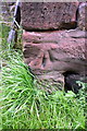
Benchmark on barn at Langton
Ordnance Survey cut mark benchmark described on the Bench Mark Database at http://www.bench-marks.org.uk/bm70026
Image: © Roger Templeman
Taken: 28 Aug 2015
0.01 miles
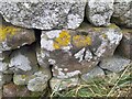
2
Ordnance Survey Cut Mark
This OS cut mark can be found on the barn at Langton Farm. It marks a point 159.602m above mean sea level.
Image: © Adrian Dust
Taken: 25 Oct 2023
0.01 miles
3
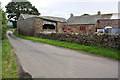
Farm buildings at Langton
There is an OS benchmark Image on the road face of the far barn about 4m beyond a GR letter box in the wall
Image: © Roger Templeman
Taken: 28 Aug 2015
0.02 miles
4
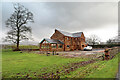
House nearly finished, Langton
The fresh local sandstone construction looks quite colourful but will no doubt weather quite quickly to be a match for the other nearby properties. Open eaves on the nearest part of the building show that there is still work to do on the house, but the next main challenge will surely be the garden. It's a heavy clay soil left by the retreat of the Eden Valley glacier, but at least the site is not beset by the sort of rubble often seen on building sites. I wish them luck.
Image: © Andy Waddington
Taken: 8 Jan 2022
0.03 miles
6
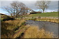
Farm Ford at Langton
This farm ford is found on the Hilton Beck at Langton.
Image: © John Walton
Taken: 16 Mar 2014
0.11 miles
7
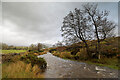
Hilton Beck at Langton
Hilton Beck runs along the northern and western edges of Brackenber Moor (Appleby Golf Course) and for the aficionado of obscure ditches who prefer their paddling not to be too scary, looks quite an attractive proposition. The level seen here is fairly high through snowmelt, but with some rain too it would perhaps be a little quicker from a put-in at Hilton to a take-out at Coupland. This view is from just upstream of the footbridge at Langton and shows what would, in lower water, be an easy ford. The beck seems relatively free of tree hazard for a lowland trip, but there is at least one livestock fence (just around a blind bend) to watch out for - there may be other hazards not seen on my walk (it was a dog walk, not a full river reconnaissance).
Image: © Andy Waddington
Taken: 8 Jan 2022
0.14 miles
8
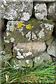
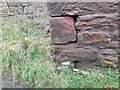
Benchmark on dry stone wall near Langton Gate
Ordnance Survey pivot benchmark described on the Bench Mark Database at http://www.bench-marks.org.uk/bm69944
Image: © Roger Templeman
Taken: 28 Aug 2015
0.17 miles
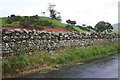
9
Ordnance Survey Pivot
This OS pivot can be found on the wall SW side of the road. It marks a point 164.857m above mean sea level.
Image: © Adrian Dust
Taken: 25 Oct 2023
0.17 miles
10
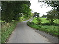
Minor road NE of Langton Gate
There is an OS benchmark Image on a stone in the dry stone wall above the blue notebook
Image: © Roger Templeman
Taken: 28 Aug 2015
0.18 miles