IMAGES TAKEN NEAR TO
Castle View Road, APPLEBY-IN-WESTMORLAND, CA16 6HH
Introduction
This page details the photographs taken nearby to Castle View Road, CA16 6HH by members of the Geograph project.
The Geograph project started in 2005 with the aim of publishing, organising and preserving representative images for every square kilometre of Great Britain, Ireland and the Isle of Man.

There are currently over 7.5m images from over14,400 individuals and you can help contribute to the project by visiting https://www.geograph.org.uk
Image Map
Images are licensed for reuse under creativecommons.org/licenses/by-sa/2.0
Notes
- Clicking on the map will re-center to the selected point.
- The higher the marker number, the further away the image location is from the centre of the postcode.
Image Listing (303 Images Found)
Images are licensed for reuse under creativecommons.org/licenses/by-sa/2.0
Image
Details
Distance
1
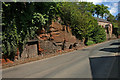
Permian Red Sandstone
Exposure of an aeolian sandstone in a road cutting at Appleby.
Image: © Helen Wilkinson
Taken: 12 May 2009
0.07 miles
2
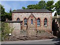
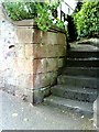
Kingdom Hall, The Sands
Former Primitive Methodist Church built into the sandstone outcrop. Now used as a Jehovah’s Witness’ Kingdom Hall.
Image: © Andrew Curtis
Taken: 6 May 2011
0.07 miles
3
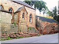
Kingdom Hall
Chapel which appears to be located in an excavated sandstone formation.
Image: © Roger Templeman
Taken: 26 Jun 2010
0.07 miles
4
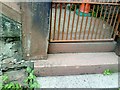
Kingdom Hall benchmark
Ordnance Survey pivot benchmark with arrow cuts on left hand side of vertical face of the step at the entrance to the chapel Image Further information on the mark is on the Bench Mark Database at http://www.bench-marks.org.uk/bm24347.
Image: © Roger Templeman
Taken: 26 Jun 2010
0.07 miles
5
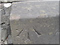
Ordnance Survey Cut Mark with Pivot
This mark can be found on the stone steps of Kingdom Hall.
For more detail see :
Image: © Peter Wood
Taken: 4 Jun 2012
0.07 miles
6
Benchmark on Bongate House
Ordnance Survey 1844 cut mark benchmark on wall at entrance to Bongate House. Further details of the mark can be found on the Bench Mark Database at http://www.bench-marks.org.uk/bm24348
Image: © Roger Templeman
Taken: 26 Jun 2010
0.07 miles
7
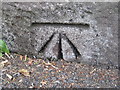
Ordnance Survey Cut Mark
This mark can be found at the entrance to Bongate House.
For more detail see : http://www.bench-marks.org.uk/bm24348
Image: © Peter Wood
Taken: 4 Jun 2012
0.07 miles
8
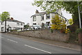
Bongate House, Bongate
There is an OS benchmark Image on the base of the wall left of the steps at the right hand side of the image
Image: © Roger Templeman
Taken: 26 May 2015
0.08 miles
10
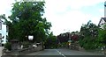
Rock cutting, The Sands, Appleby
This road was constructed c.1812 and became the A66 trunk road until the bypass was made recently. The curves were not a problem in the 19C; turnpike trust could hardly have anticipated the size and speed of 20C traffic!
Image: © Humphrey Bolton
Taken: 3 Nov 2006
0.10 miles