IMAGES TAKEN NEAR TO
North View, APPLEBY-IN-WESTMORLAND, CA16 6HB
Introduction
This page details the photographs taken nearby to North View, CA16 6HB by members of the Geograph project.
The Geograph project started in 2005 with the aim of publishing, organising and preserving representative images for every square kilometre of Great Britain, Ireland and the Isle of Man.

There are currently over 7.5m images from over14,400 individuals and you can help contribute to the project by visiting https://www.geograph.org.uk
Image Map
Images are licensed for reuse under creativecommons.org/licenses/by-sa/2.0
Notes
- Clicking on the map will re-center to the selected point.
- The higher the marker number, the further away the image location is from the centre of the postcode.
Image Listing (42 Images Found)
Images are licensed for reuse under creativecommons.org/licenses/by-sa/2.0
Image
Details
Distance
1
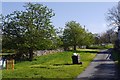
Green, Great Asby
A goat called Snoopy?
Image: © Richard Webb
Taken: 9 May 2016
0.01 miles
3
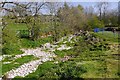
Asby Gill
Often the burn flows underground through the limestone. In wet spells the cave system fills and water flows above ground Image
Image: © Richard Webb
Taken: 9 May 2016
0.03 miles
4
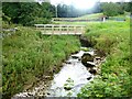
Footbridge over Asby Gill
At the head of Great Asby village.
Image: © Oliver Dixon
Taken: 8 Aug 2019
0.04 miles
5

Great Asby
A bridge over the sometimes underground Asby Gill. Limestone country with some fine karst features. There are substantial cave systems here.
Image: © Richard Webb
Taken: 9 May 2016
0.05 miles
6
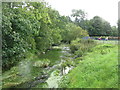
Asby Beck
Looking up-river in the southern outskirts of Great Asby.
Image: © G Laird
Taken: 18 Sep 2013
0.05 miles
7
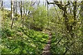
Path, Asby Gill
Passing beneath a farm beside a seasonal stream in limestone country.
Image: © Richard Webb
Taken: 9 May 2016
0.06 miles
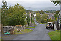
8
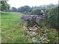
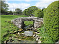
The packhorse bridge at Great Asby
Great Asby is an attractive village with old cottages and a hall built in 1670. Asby Beck flows through the middle of the village with a long green up both grassy banks either side. Dale Beck is a tributary of Asby Beck which it meets at the southern end of the village. The packhorse bridge over Dale Beck probably dates from the 17th century when it formed part of the original road into the village.
Image: © Marathon
Taken: 26 Aug 2018
0.06 miles
9
Dale Beck
Old bridge crossing Dale Beck in Great Asby.
Image: © Peter McDermott
Taken: 27 Dec 2009
0.06 miles
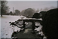
10
Packhorse Bridge Great Asby
Dale Beck enters the village under this old bridge.I am stood on the new bridge.To the left is the path we are taking to walk to Gaythorne Hall, then on to Crosby Ravensworth.
Image: © Martin Dawes
Taken: 16 May 2012
0.06 miles