IMAGES TAKEN NEAR TO
Heights, APPLEBY-IN-WESTMORLAND, CA16 6EW
Introduction
This page details the photographs taken nearby to CA16 6EW by members of the Geograph project.
The Geograph project started in 2005 with the aim of publishing, organising and preserving representative images for every square kilometre of Great Britain, Ireland and the Isle of Man.

There are currently over 7.5m images from over14,400 individuals and you can help contribute to the project by visiting https://www.geograph.org.uk
Image Map
Images are licensed for reuse under creativecommons.org/licenses/by-sa/2.0
Notes
- Clicking on the map will re-center to the selected point.
- The higher the marker number, the further away the image location is from the centre of the postcode.
Image Listing (3 Images Found)
Images are licensed for reuse under creativecommons.org/licenses/by-sa/2.0
Image
Details
Distance
1
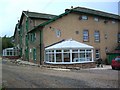
Breaks Hall
At the time this was taken was undergoing a major refurb.
Image: © Keith Wright
Taken: 22 Oct 2007
0.04 miles
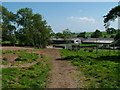
3
The road to Breaks Hall and a small area of trees
Breaks Hall Image is on the extreme left, just into Image The trees in the centre are a triangular plantation by another access road to the farm
Image: © David Smith
Taken: 3 Oct 2016
0.14 miles