IMAGES TAKEN NEAR TO
Great Asby, APPLEBY-IN-WESTMORLAND, CA16 6ES
Introduction
This page details the photographs taken nearby to CA16 6ES by members of the Geograph project.
The Geograph project started in 2005 with the aim of publishing, organising and preserving representative images for every square kilometre of Great Britain, Ireland and the Isle of Man.

There are currently over 7.5m images from over14,400 individuals and you can help contribute to the project by visiting https://www.geograph.org.uk
Image Map
Images are licensed for reuse under creativecommons.org/licenses/by-sa/2.0
Notes
- Clicking on the map will re-center to the selected point.
- The higher the marker number, the further away the image location is from the centre of the postcode.
Image Listing (3 Images Found)
Images are licensed for reuse under creativecommons.org/licenses/by-sa/2.0
Image
Details
Distance
1
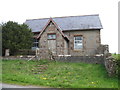
Wesleyan Chapel at roadside
Built in 1879, close to Catharine Holme.
Image: © Martin Dawes
Taken: 16 May 2012
0.06 miles
2
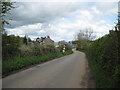
Lane to Bow Bridge
Bowbridge House Farm on the left
Image: © Martin Dawes
Taken: 16 May 2012
0.23 miles
3
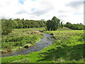
Asby Beck
About 1 mile up-river from Rutter Force.
Image: © G Laird
Taken: 18 Sep 2013
0.25 miles