IMAGES TAKEN NEAR TO
Knock, APPLEBY-IN-WESTMORLAND, CA16 6DT
Introduction
This page details the photographs taken nearby to CA16 6DT by members of the Geograph project.
The Geograph project started in 2005 with the aim of publishing, organising and preserving representative images for every square kilometre of Great Britain, Ireland and the Isle of Man.

There are currently over 7.5m images from over14,400 individuals and you can help contribute to the project by visiting https://www.geograph.org.uk
Image Map
Images are licensed for reuse under creativecommons.org/licenses/by-sa/2.0
Notes
- Clicking on the map will re-center to the selected point.
- The higher the marker number, the further away the image location is from the centre of the postcode.
Image Listing (6 Images Found)
Images are licensed for reuse under creativecommons.org/licenses/by-sa/2.0
Image
Details
Distance
4
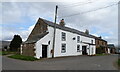
Knock Cross
The house in the distance is on the Long Marton - Knock road at Knock Cross.
Image: © Stephen McKay
Taken: 8 Oct 2006
0.07 miles
5
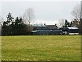
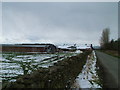
Buildings at Glebelands
A farm just north of Knock Cross. The income from glebe land was used to support a parish priest.
Image: © Christine Johnstone
Taken: 16 Feb 2017
0.16 miles
6
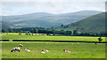
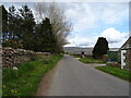
Field with sheep east of Glebelands
Glebelands is a farm close to the small village of Knock.
The land ahead in the view is named on OS maps as Knock Moor; that's presumably an historical name as it's moorland no more - now fully integrated farmland.
The two skyline mountains are Little Dun Fell and Great Dun Fell.
Image: © Trevor Littlewood
Taken: 25 Jul 2017
0.18 miles