IMAGES TAKEN NEAR TO
Colby, APPLEBY-IN-WESTMORLAND, CA16 6BB
Introduction
This page details the photographs taken nearby to CA16 6BB by members of the Geograph project.
The Geograph project started in 2005 with the aim of publishing, organising and preserving representative images for every square kilometre of Great Britain, Ireland and the Isle of Man.

There are currently over 7.5m images from over14,400 individuals and you can help contribute to the project by visiting https://www.geograph.org.uk
Image Map
Images are licensed for reuse under creativecommons.org/licenses/by-sa/2.0
Notes
- Clicking on the map will re-center to the selected point.
- The higher the marker number, the further away the image location is from the centre of the postcode.
Image Listing (9 Images Found)
Images are licensed for reuse under creativecommons.org/licenses/by-sa/2.0
Image
Details
Distance
2
Farmland south of Hawkrigg Farm
On the north side of the road to Colby.
Image: © Christine Johnstone
Taken: 14 Feb 2017
0.21 miles
4
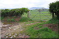
Gateway to fields of Hawkrigg Farm
Wooden gateposts have replaced original stone ones
Image: © Roger Templeman
Taken: 13 May 2015
0.21 miles
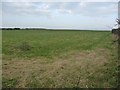
5
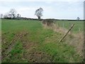
Field boundary, south of Hawkrigg Farm
A post and wire fence fills the long gap in the hedge.
Image: © Christine Johnstone
Taken: 14 Feb 2017
0.21 miles
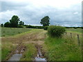
6
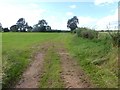
Field and farm track near Hawkrigg Farm
Image: © Oliver Dixon
Taken: 8 Aug 2019
0.21 miles
7
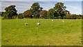
Hawkrigg Farm
Sheep grazing on fields near Hawkrigg Farm.
Image: © Peter McDermott
Taken: 16 Sep 2024
0.21 miles
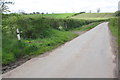
8
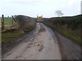
Narrow road, normal-sized lorry
Heading north-east to Colby.
Image: © Christine Johnstone
Taken: 14 Feb 2017
0.22 miles
9
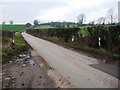
The road south-west out of Colby
Heading towards King's Meaburn.
Image: © Christine Johnstone
Taken: 14 Feb 2017
0.23 miles