IMAGES TAKEN NEAR TO
Colby, APPLEBY-IN-WESTMORLAND, CA16 6BA
Introduction
This page details the photographs taken nearby to CA16 6BA by members of the Geograph project.
The Geograph project started in 2005 with the aim of publishing, organising and preserving representative images for every square kilometre of Great Britain, Ireland and the Isle of Man.

There are currently over 7.5m images from over14,400 individuals and you can help contribute to the project by visiting https://www.geograph.org.uk
Image Map
Images are licensed for reuse under creativecommons.org/licenses/by-sa/2.0
Notes
- Clicking on the map will re-center to the selected point.
- The higher the marker number, the further away the image location is from the centre of the postcode.
Image Listing (16 Images Found)
Images are licensed for reuse under creativecommons.org/licenses/by-sa/2.0
Image
Details
Distance
3
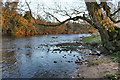
Stepping Stones at Colby Laithes
Far too slippery to attempt a crossing today. These stepping stones are found on the River Eden just outside Appleby-in-Westmorland.
Image: © John Walton
Taken: 18 Sep 2023
0.05 miles
4
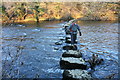
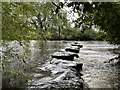
Stepping Stones Across the River Eden
Very slippery, with deep cold water both sides, this crossing is for the brave and well-balanced!
Image: © Bob Jenkins
Taken: 29 Dec 2008
0.06 miles
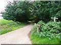
5
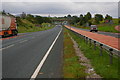
Section of the old A66 west of Appleby
This was the main A66 road before the construction of the present road. The sides have become overgrown giving a slightly false impression of the original road width.
Image: © Roger Templeman
Taken: 26 Jun 2010
0.09 miles
6
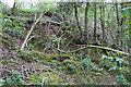
Embankment on south side of the old A66
The Ordnance Survey cut a benchmark on a wall here in 1844, but the wall appears to have collapsed and lost. See http://www.bench-marks.org.uk/bm48382 on the Bench Mark Database for details.
Image: © Roger Templeman
Taken: 7 May 2015
0.09 miles
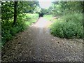
8
Public footpath to Appleby
Heading south-east from its junction with the Colby - Colby Laithes bridleway. All these rights of way are on concrete farm tracks.
Image: © Christine Johnstone
Taken: 13 Oct 2016
0.17 miles
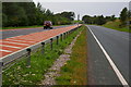
9
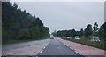
Nearing the end of the dual carriageway, A66
Image: © N Chadwick
Taken: 23 Jun 2012
0.17 miles
10
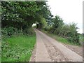
Public bridleway to Colby
Heading south-west from Colby Laithes on a concrete farm track.
Image: © Christine Johnstone
Taken: 13 Oct 2016
0.18 miles