IMAGES TAKEN NEAR TO
APPLEBY-IN-WESTMORLAND, CA16 6AD
Introduction
This page details the photographs taken nearby to CA16 6AD by members of the Geograph project.
The Geograph project started in 2005 with the aim of publishing, organising and preserving representative images for every square kilometre of Great Britain, Ireland and the Isle of Man.

There are currently over 7.5m images from over14,400 individuals and you can help contribute to the project by visiting https://www.geograph.org.uk
Image Map
Images are licensed for reuse under creativecommons.org/licenses/by-sa/2.0
Notes
- Clicking on the map will re-center to the selected point.
- The higher the marker number, the further away the image location is from the centre of the postcode.
Image Listing (7 Images Found)
Images are licensed for reuse under creativecommons.org/licenses/by-sa/2.0
Image
Details
Distance
1
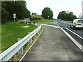
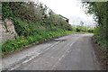
A66 by Chapel Wood west of Appleby
Junction from A66 to Crackenthorpe Hall on road which looks like part of an old road.
Image: © Roger Templeman
Taken: 26 Jun 2010
0.12 miles
2
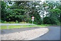
The beginnings of an old stretch of the A66
The A66 has been upgraded and straightened, leaving many of the windier bits behind.
Image: © N Chadwick
Taken: 16 Jul 2011
0.12 miles

5
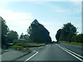
Chapel Wood, on the north bank of the River Eden
The A66, beyond the trees, is out of sight but not out of earshot.
Image: © Christine Johnstone
Taken: 13 Oct 2016
0.16 miles
6
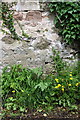
Benchmark on farm wall at Chapel Hill
Ordnance Survey cut mark benchmark described on the Bench Mark Database at http://www.bench-marks.org.uk/bm66544
Image: © Roger Templeman
Taken: 7 May 2015
0.17 miles
7
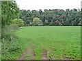
Old road towards Appleby at Chapel Hill
There is an OS benchmark Image on the wall near the left hand edge of the image, left of some overhanging ivy
Image: © Roger Templeman
Taken: 7 May 2015
0.17 miles