IMAGES TAKEN NEAR TO
Lonsdale Place, MARYPORT, CA15 8TP
Introduction
This page details the photographs taken nearby to Lonsdale Place, CA15 8TP by members of the Geograph project.
The Geograph project started in 2005 with the aim of publishing, organising and preserving representative images for every square kilometre of Great Britain, Ireland and the Isle of Man.

There are currently over 7.5m images from over14,400 individuals and you can help contribute to the project by visiting https://www.geograph.org.uk
Image Map
Images are licensed for reuse under creativecommons.org/licenses/by-sa/2.0
Notes
- Clicking on the map will re-center to the selected point.
- The higher the marker number, the further away the image location is from the centre of the postcode.
Image Listing (2 Images Found)
Images are licensed for reuse under creativecommons.org/licenses/by-sa/2.0
Image
Details
Distance
1
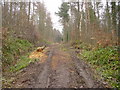
Dismantled Tramway Flimby Great Wood
This tramway is quite steep, and met the mineral railway at Robin Hood Pit. The sides are currently being cleared of trees and undergrowth to allow more light in, help dry the footpath out and provide a more pleasant route.
Image: © Bob Jenkins
Taken: 9 Jan 2006
0.13 miles
2
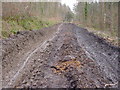
Dismembered Dismantled Tramway, Flimby Great Wood
Heavy forestry machinery and motorcycle riders have produced this mess which was Image a few weeks previous.
Image: © Bob Jenkins
Taken: 16 Mar 2006
0.13 miles