IMAGES TAKEN NEAR TO
Woodview, Seaton Road, MARYPORT, CA15 8SS
Introduction
This page details the photographs taken nearby to Woodview, Seaton Road, CA15 8SS by members of the Geograph project.
The Geograph project started in 2005 with the aim of publishing, organising and preserving representative images for every square kilometre of Great Britain, Ireland and the Isle of Man.

There are currently over 7.5m images from over14,400 individuals and you can help contribute to the project by visiting https://www.geograph.org.uk
Image Map
Images are licensed for reuse under creativecommons.org/licenses/by-sa/2.0
Notes
- Clicking on the map will re-center to the selected point.
- The higher the marker number, the further away the image location is from the centre of the postcode.
Image Listing (5 Images Found)
Images are licensed for reuse under creativecommons.org/licenses/by-sa/2.0
Image
Details
Distance
1
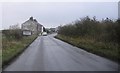
Entrance to Broughton Moor.
A country road approaching the village.
Image: © John Holmes
Taken: 20 Nov 2005
0.08 miles
2
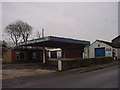
Standingstones Garage Broughton Moor
Standing Stones appears to have been the name attributed to the general area outside the agglomeration named Broughton Moor, which was centred around the crossroads. New bungalows are planned for the site.
Image: © Bob Jenkins
Taken: 6 Jan 2006
0.16 miles
3
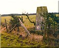
Triangulation pillar at Broughton Moor
The pillar was destroyed in 1992. More information may be found at http://trigpointing.uk/trig/1695
Image: © Roger Templeman
Taken: 30 Dec 1980
0.21 miles
4
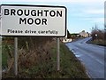
Entrance to Broughton Moor.
With a bend in the road entering the outskirts of Broughton Moor the "Please drive carefully" does seem appropriate.
Image: © John Holmes
Taken: 21 Dec 2005
0.24 miles
5
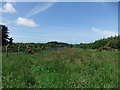
Path on Broughton Moor
The fence remains more than 20 years after closure.
Image: © David Brown
Taken: 23 Jun 2015
0.24 miles