IMAGES TAKEN NEAR TO
Main Road, MARYPORT, CA15 8RW
Introduction
This page details the photographs taken nearby to Main Road, CA15 8RW by members of the Geograph project.
The Geograph project started in 2005 with the aim of publishing, organising and preserving representative images for every square kilometre of Great Britain, Ireland and the Isle of Man.

There are currently over 7.5m images from over14,400 individuals and you can help contribute to the project by visiting https://www.geograph.org.uk
Image Map
Images are licensed for reuse under creativecommons.org/licenses/by-sa/2.0
Notes
- Clicking on the map will re-center to the selected point.
- The higher the marker number, the further away the image location is from the centre of the postcode.
Image Listing (29 Images Found)
Images are licensed for reuse under creativecommons.org/licenses/by-sa/2.0
Image
Details
Distance
1
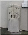
Old Milestone by the A596, Flimby, Maryport parish
Stone post by the A596, in parish of Maryport (Allerdale District), Flimby, against West face of building.
Defaced inscription once read:-
(Workington)
(4)
(Wigton)
(19)
Surveyed
Milestone Society National ID: CU_WGWO19
Image: © Milestone Society
Taken: Unknown
0.02 miles
2
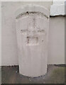
Old Milestone by the A596, Flimby, Maryport parish
Stone post by the A596, in parish of Maryport (Allerdale District), Flimby, against West face of building.
Defaced inscription once read:-
(Workington)
(4)
(Wigton)
(19)
Surveyed
Milestone Society National ID: CU_WGWO19
Image: © Barbara Todd
Taken: 2 Nov 2023
0.02 miles
4
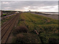
Flimby beach access.
The footpath goes under the railway.
Image: © John Holmes
Taken: 20 Nov 2005
0.06 miles
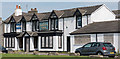
6
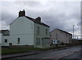
View from the footbridge at Flimby station
Looking south-west into the adjacent gridsquare, which starts near the white houses in the mid-distance.
Image: © Nigel Monckton
Taken: 10 Oct 2004
0.09 miles
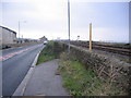
9
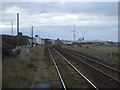
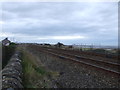
Cumbrian Coast Line towards Workington
View from Flimby Railway Station.
Image: © JThomas
Taken: 23 Nov 2019
0.12 miles
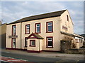
10
The Princess Royal, Flimby - June 2017
A modern pub, which appears to have closed circa 2007. It was State Managed from November 1918 until sold to John Smiths Brewing Group on 11 May 1973.
A photograph of the building in better days may be viewed: http://www.geog.port.ac.uk/webmap/thelakes/html/lgaz/lk14435.htm
Photograph is for record only - I have no connection with this business or any parties involved in the sale, and cannot advise on their products or services.
Image: © The Carlisle Kid
Taken: 19 Jun 2017
0.14 miles