IMAGES TAKEN NEAR TO
The Fothergills, MARYPORT, CA15 8PG
Introduction
This page details the photographs taken nearby to The Fothergills, CA15 8PG by members of the Geograph project.
The Geograph project started in 2005 with the aim of publishing, organising and preserving representative images for every square kilometre of Great Britain, Ireland and the Isle of Man.

There are currently over 7.5m images from over14,400 individuals and you can help contribute to the project by visiting https://www.geograph.org.uk
Image Map
Images are licensed for reuse under creativecommons.org/licenses/by-sa/2.0
Notes
- Clicking on the map will re-center to the selected point.
- The higher the marker number, the further away the image location is from the centre of the postcode.
Image Listing (10 Images Found)
Images are licensed for reuse under creativecommons.org/licenses/by-sa/2.0
Image
Details
Distance
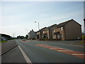
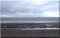
2
The Miners Arms on the A596T.
Under reconstruction.
Image: © John Holmes
Taken: 20 Nov 2005
0.06 miles
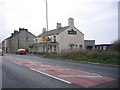
4
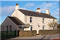
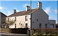
Former "Miners' Arms", Fothergill - October 2017 (1)
Early 20th century former pub, acquired by the State Management Scheme in November 1918. The pub was sold to Greenall Whitley on 5 April 1973.
See also: Image] .
John Holmes photographed the pub in November 2005, possibly just after closure - see: Image] .
Now a private dwelling with no public access.
Image: © The Carlisle Kid
Taken: 27 Oct 2017
0.08 miles
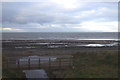
5
Former "Miners' Arms", Fothergill - October 2017 (2)
For information on this former pub, see: Image] .
Image: © The Carlisle Kid
Taken: 27 Oct 2017
0.08 miles
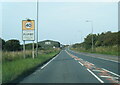
8

National Cycle Route 72, Fothergill
National Cycle Route 72 turns left here under the Cumbrian Coast Railway - Image
Image: © JThomas
Taken: 23 Nov 2019
0.20 miles
9
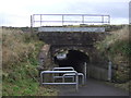
Subway beneath the Cumbrian Coast Railway
Used by National Cycle Route 72.
Image: © JThomas
Taken: 23 Nov 2019
0.21 miles
10
Forth Engineering near Maryport
Beside the Cumbrian Coast Railway.
Image: © JThomas
Taken: 23 Nov 2019
0.24 miles