IMAGES TAKEN NEAR TO
Flimby, MARYPORT, CA15 8PA
Introduction
This page details the photographs taken nearby to CA15 8PA by members of the Geograph project.
The Geograph project started in 2005 with the aim of publishing, organising and preserving representative images for every square kilometre of Great Britain, Ireland and the Isle of Man.

There are currently over 7.5m images from over14,400 individuals and you can help contribute to the project by visiting https://www.geograph.org.uk
Image Map
Images are licensed for reuse under creativecommons.org/licenses/by-sa/2.0
Notes
- Clicking on the map will re-center to the selected point.
- The higher the marker number, the further away the image location is from the centre of the postcode.
Image Listing (13 Images Found)
Images are licensed for reuse under creativecommons.org/licenses/by-sa/2.0
Image
Details
Distance
1
Tollhouse by the A596, Main Road, Risehow
Tollhouse by the A596, in the parish of Maryport (Allerdale District), Risehow, Main Road.
To be surveyed
Milestone Society National ID: CB.MAR
Image: © Milestone Society
Taken: Unknown
0.02 miles
3
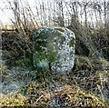
Old Milestone by the A596 at Risehow
Carved stone post by the A596, in parish of MARYPORT (ALLERDALE District), Risehow, on grass verge, on East side of road. Wigton curved red stone, erected by the Cockermouth & Maryport turnpike trust in the 19th century.
Inscription once read:-
: (WIGTON 18) : : (WORKINGTON 5) :
Milestone Society National ID: CU_WOMP02.
Image: © CF Smith
Taken: 19 Feb 2010
0.04 miles
4
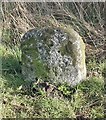
Old Milestone by the A596, Risehow, Maryport Parish
Wigton curved red stone by the A596, in parish of Maryport (Allerdale District), Risehow, on grass verge.
Inscription once read:- : (Wigton 18 / Workington 5) :
Surveyed
Milestone Society National ID: CU_WGWO18
Image: © Milestone Society
Taken: Unknown
0.04 miles
5
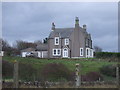
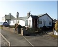
Solway Crest
House above the Cumbrian Coast Railway.
Image: © JThomas
Taken: 23 Nov 2019
0.13 miles
6
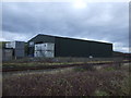
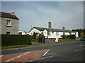
Forth Engineering near Maryport
Beside the Cumbrian Coast Railway.
Image: © JThomas
Taken: 23 Nov 2019
0.16 miles
8
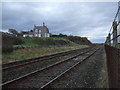
National Cycle Route 72 towards Flimby
Beside the Cumbrian Coast Railway.
Image: © JThomas
Taken: 23 Nov 2019
0.18 miles
9
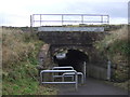
Subway beneath the Cumbrian Coast Railway
Used by National Cycle Route 72.
Image: © JThomas
Taken: 23 Nov 2019
0.19 miles
10

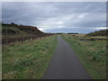
National Cycle Route 72, Fothergill
National Cycle Route 72 turns left here under the Cumbrian Coast Railway - Image
Image: © JThomas
Taken: 23 Nov 2019
0.20 miles