IMAGES TAKEN NEAR TO
Mosedale Crescent, MARYPORT, CA15 8HH
Introduction
This page details the photographs taken nearby to Mosedale Crescent, CA15 8HH by members of the Geograph project.
The Geograph project started in 2005 with the aim of publishing, organising and preserving representative images for every square kilometre of Great Britain, Ireland and the Isle of Man.

There are currently over 7.5m images from over14,400 individuals and you can help contribute to the project by visiting https://www.geograph.org.uk
Image Map
Images are licensed for reuse under creativecommons.org/licenses/by-sa/2.0
Notes
- Clicking on the map will re-center to the selected point.
- The higher the marker number, the further away the image location is from the centre of the postcode.
Image Listing (6 Images Found)
Images are licensed for reuse under creativecommons.org/licenses/by-sa/2.0
Image
Details
Distance
1
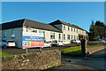
Victoria Cottage Hospital
Located on Maryport's Ewanrigg Road.
Image: © Mary and Angus Hogg
Taken: 15 Dec 2017
0.06 miles
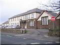
3
Glasson Rugby League Football Club
Ewanrigg Road, Maryport.
Image: © Oliver Dixon
Taken: 10 Apr 2008
0.09 miles
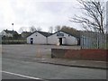
4
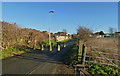
Open Space at Netherton
Viewed from the corner of Gavel Street on the south side of Maryport on a lovely mid-December day.
Image: © Mary and Angus Hogg
Taken: 15 Dec 2017
0.19 miles
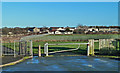
5
Sandy Lonning
Sandy Lonning is closed to vehicles here.
Image: © Mary and Angus Hogg
Taken: 15 Dec 2017
0.23 miles
6
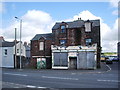
No5 Main Street, Maryport
I would say it's seen better trading days
Image: © Alexander P Kapp
Taken: 5 Aug 2007
0.24 miles