IMAGES TAKEN NEAR TO
Sandy Lonning, MARYPORT, CA15 8AU
Introduction
This page details the photographs taken nearby to Sandy Lonning, CA15 8AU by members of the Geograph project.
The Geograph project started in 2005 with the aim of publishing, organising and preserving representative images for every square kilometre of Great Britain, Ireland and the Isle of Man.

There are currently over 7.5m images from over14,400 individuals and you can help contribute to the project by visiting https://www.geograph.org.uk
Image Map
Images are licensed for reuse under creativecommons.org/licenses/by-sa/2.0
Notes
- Clicking on the map will re-center to the selected point.
- The higher the marker number, the further away the image location is from the centre of the postcode.
Image Listing (32 Images Found)
Images are licensed for reuse under creativecommons.org/licenses/by-sa/2.0
Image
Details
Distance
1
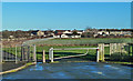
Open Space at Netherton
Viewed from the corner of Gavel Street on the south side of Maryport on a lovely mid-December day.
Image: © Mary and Angus Hogg
Taken: 15 Dec 2017
0.05 miles
3
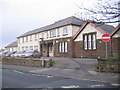
Victoria Cottage Hospital
Located on Maryport's Ewanrigg Road.
Image: © Mary and Angus Hogg
Taken: 15 Dec 2017
0.08 miles
4
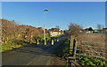
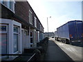
Sandy Lonning
Sandy Lonning is closed to vehicles here.
Image: © Mary and Angus Hogg
Taken: 15 Dec 2017
0.09 miles
5
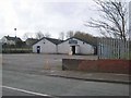
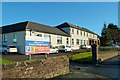
Glasson Rugby League Football Club
Ewanrigg Road, Maryport.
Image: © Oliver Dixon
Taken: 10 Apr 2008
0.10 miles
6
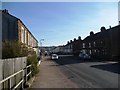
Gavel Street, Maryport
Seen from its junction with the A596.
Image: © Christine Johnstone
Taken: 28 Feb 2013
0.13 miles
7
The A596, Maryport
Residents might like a by-pass.
Image: © Christine Johnstone
Taken: 28 Feb 2013
0.14 miles
8
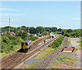
153352 leaving Maryport station - June 2017
A once substantial railway layout has been heavily rationalised in recent years. A basic system seems to deserve only a basic service as single diesel unit 153352 pulls out of Maryport station with the 12.08 passenger working from Carlisle to Barrow-on-Furness.
A view of the former Maryport station may be seen: Image] .
Image: © The Carlisle Kid
Taken: 19 Jun 2017
0.16 miles
9
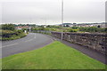
Road to the railway station from Curzon Street
There is an OS benchmark Image on the wall on the right hand side of the image
Image: © Roger Templeman
Taken: 27 Jun 2012
0.17 miles
10
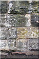
Benchmark on wall beside railway near Curzon Street bridge
Ordnance Survey cut mark benchmark described on the Bench Mark Database at http://www.bench-marks.org.uk/bm43414
Image: © Roger Templeman
Taken: 27 Jun 2012
0.17 miles