IMAGES TAKEN NEAR TO
Sunnyslack, MARYPORT, CA15 7RL
Introduction
This page details the photographs taken nearby to Sunnyslack, CA15 7RL by members of the Geograph project.
The Geograph project started in 2005 with the aim of publishing, organising and preserving representative images for every square kilometre of Great Britain, Ireland and the Isle of Man.

There are currently over 7.5m images from over14,400 individuals and you can help contribute to the project by visiting https://www.geograph.org.uk
Image Map
Images are licensed for reuse under creativecommons.org/licenses/by-sa/2.0
Notes
- Clicking on the map will re-center to the selected point.
- The higher the marker number, the further away the image location is from the centre of the postcode.
Image Listing (11 Images Found)
Images are licensed for reuse under creativecommons.org/licenses/by-sa/2.0
Image
Details
Distance
1
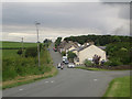
Harker Marsh
Looking along the road which passes the row of houses which make up Harker Marsh.
Image: © Graham Robson
Taken: 17 Jun 2016
0.04 miles
3
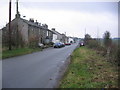
Harker Marsh.
Previously known as Sunny Slack.
Image: © John Holmes
Taken: 20 Nov 2005
0.08 miles
5
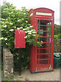
Telephone box, Harker Marsh
Adjacently situated telephone box and post box in Harker Marsh. I did check to confirm that the rather faded telephone box did still have a telephone in it when I photographed it.
Image: © Graham Robson
Taken: 17 Jun 2016
0.13 miles
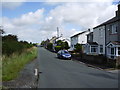
6
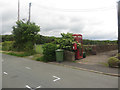
Postbox and phone box in Harker Marsh
A postbox and traditional red telephone box at the eastern end of the hamlet of Harker Marsh.
Image: © Graham Robson
Taken: 17 Jun 2016
0.14 miles
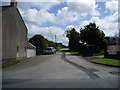
7
Footpath at New Hall Farm
This is in line with the route of the path on the map, and there is a footpath marker on a post ahead. However it becomes impassable, and the practical route is to take the track further to the right of here.
Image: © Bill Boaden
Taken: 27 Aug 2019
0.14 miles
8
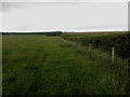
Footpath following a field boundary
A public footpath between Harker Marsh and Maryport follows the edge of this grass field.
Image: © Graham Robson
Taken: 17 Jun 2016
0.15 miles
9
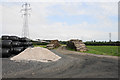
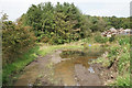
Piles and pylons at New Hall Farm
There are piles of logs, silage bales and gravel.
Image: © Bill Boaden
Taken: 27 Aug 2019
0.15 miles
10
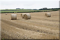
Harvested field near Harker Marsh
The straw bales are still awaiting collection.
Image: © Bill Boaden
Taken: 27 Aug 2019
0.24 miles