IMAGES TAKEN NEAR TO
Dearham, MARYPORT, CA15 7RA
Introduction
This page details the photographs taken nearby to CA15 7RA by members of the Geograph project.
The Geograph project started in 2005 with the aim of publishing, organising and preserving representative images for every square kilometre of Great Britain, Ireland and the Isle of Man.

There are currently over 7.5m images from over14,400 individuals and you can help contribute to the project by visiting https://www.geograph.org.uk
Image Map
Images are licensed for reuse under creativecommons.org/licenses/by-sa/2.0
Notes
- Clicking on the map will re-center to the selected point.
- The higher the marker number, the further away the image location is from the centre of the postcode.
Image Listing (10 Images Found)
Images are licensed for reuse under creativecommons.org/licenses/by-sa/2.0
Image
Details
Distance
2
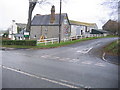
Entrance to old tip and council yard
Image: © Alexander P Kapp
Taken: 5 Aug 2007
0.05 miles
3
The A594 at Hayborough heading for Maryport
Image: © James Denham
Taken: 3 Jul 2010
0.09 miles
4
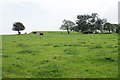
Cattle below a reservoir
Looking uphill from Hayborough Farm.
Image: © Bill Boaden
Taken: 27 Aug 2019
0.10 miles
5
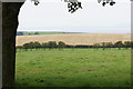
Field above Maryport
The Solway Firth and Scottish hills are less visible on this day than they often are.
Image: © Bill Boaden
Taken: 27 Aug 2019
0.12 miles
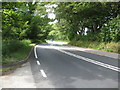
6

Maryport Road
Between Dearham and Ellenborough, about to begin a descent towards Maryport on the coast.
Image: © Bill Boaden
Taken: 27 Aug 2019
0.12 miles
7
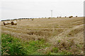
Harvested field near Hayborough Farm
The straw bales are still awaiting collection.
Image: © Bill Boaden
Taken: 27 Aug 2019
0.15 miles
8
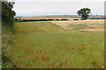
Wild flower strip above Maryport
A way to earn an EU subsidy.
Image: © Bill Boaden
Taken: 27 Aug 2019
0.18 miles
9
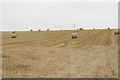
Harvested field near Dearham
The straw bales are still awaiting collection.
Image: © Bill Boaden
Taken: 27 Aug 2019
0.20 miles
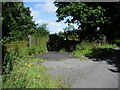
10
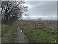
Track from Crosshow Road towards Maryport
Track leading from the road towards Maryport.
Image: © Robert Matin
Taken: 10 Mar 2013
0.22 miles