IMAGES TAKEN NEAR TO
Grasmere Terrace, MARYPORT, CA15 7QD
Introduction
This page details the photographs taken nearby to Grasmere Terrace, CA15 7QD by members of the Geograph project.
The Geograph project started in 2005 with the aim of publishing, organising and preserving representative images for every square kilometre of Great Britain, Ireland and the Isle of Man.

There are currently over 7.5m images from over14,400 individuals and you can help contribute to the project by visiting https://www.geograph.org.uk
Image Map
Images are licensed for reuse under creativecommons.org/licenses/by-sa/2.0
Notes
- Clicking on the map will re-center to the selected point.
- The higher the marker number, the further away the image location is from the centre of the postcode.
Image Listing (29 Images Found)
Images are licensed for reuse under creativecommons.org/licenses/by-sa/2.0
Image
Details
Distance
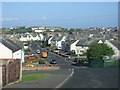
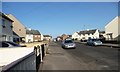
2
Church Terrace, Maryport
Looking down a long terraced street in Maryport.
Image: © Graham Robson
Taken: 17 Jun 2016
0.08 miles
3
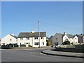
Derwent Avenue, Netherton, Maryport
East of Bradbury Avenue.
Image: © Christine Johnstone
Taken: 28 Feb 2013
0.11 miles
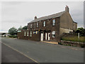
4
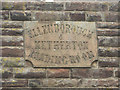
Inscribed stone, Ellenborough Social Club
An inscribed stone in the front wall of the building which is now Ellenborough Social Club. Image shows the building of which the stone is a detail.
Image: © Graham Robson
Taken: 17 Jun 2016
0.12 miles
5
Bradbury Avenue, Netherton, Maryport
Running from Victory Crescent to Ellenborough Road.
Image: © Christine Johnstone
Taken: 28 Feb 2013
0.12 miles
6
Ellenborough Social Club
Ellenborough Social Club on Church Terrace in Maryport. The club occupies a building which was originally built as the Ellenborough and Netherton Reading Room (see Image).
Image: © Graham Robson
Taken: 17 Jun 2016
0.12 miles
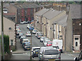
7
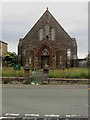
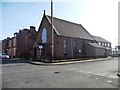
Derelict Methodist Church, Church Terrace, Maryport
This church building on Church Terrace is obviously no longer in use. The overgrown grass at the front and smashed windows suggest that the building is no longer cared for after falling out of use.
Image: © Graham Robson
Taken: 17 Jun 2016
0.13 miles
8
Former Post Office In Rydal Avenue
The closed corner post office still shows on the map.
Image: © Mary and Angus Hogg
Taken: 15 Dec 2017
0.13 miles
9
Netherton Methodist Chapel
For sale, with outline planning consent for its demolition and replacement with two semi-detached houses.
Image: © Christine Johnstone
Taken: 28 Feb 2013
0.13 miles
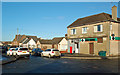
10
Bradbury Avenue
The junction of Maryport's Bradbury Avenue and Victory Crescent.
Image: © Mary and Angus Hogg
Taken: 15 Dec 2017
0.14 miles