IMAGES TAKEN NEAR TO
Dearham, MARYPORT, CA15 7LD
Introduction
This page details the photographs taken nearby to CA15 7LD by members of the Geograph project.
The Geograph project started in 2005 with the aim of publishing, organising and preserving representative images for every square kilometre of Great Britain, Ireland and the Isle of Man.

There are currently over 7.5m images from over14,400 individuals and you can help contribute to the project by visiting https://www.geograph.org.uk
Image Map
Images are licensed for reuse under creativecommons.org/licenses/by-sa/2.0
Notes
- Clicking on the map will re-center to the selected point.
- The higher the marker number, the further away the image location is from the centre of the postcode.
Image Listing (4 Images Found)
Images are licensed for reuse under creativecommons.org/licenses/by-sa/2.0
Image
Details
Distance
1
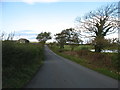
Lane near Woodside Farm
On the right is a circular pond, presumably artificial, with a circular island in its centre.
Image: © David Purchase
Taken: 13 Oct 2016
0.03 miles
2
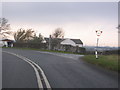
A594 to Dearham junction.
The white lines really are like that.
Image: © John Holmes
Taken: 20 Nov 2005
0.19 miles
4
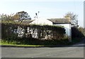
Tollhouse by the A594, Dovenby
Tollhouse by the A594, in the parish of Bridekirk (Allerdale District), Tollbar Cottage, Dovenby, CA15 7LD.
To be surveyed
Milestone Society National ID: CB.BRD
Image: © Milestone Society
Taken: Unknown
0.21 miles