IMAGES TAKEN NEAR TO
Town Head, MARYPORT, CA15 7JW
Introduction
This page details the photographs taken nearby to Town Head, CA15 7JW by members of the Geograph project.
The Geograph project started in 2005 with the aim of publishing, organising and preserving representative images for every square kilometre of Great Britain, Ireland and the Isle of Man.

There are currently over 7.5m images from over14,400 individuals and you can help contribute to the project by visiting https://www.geograph.org.uk
Image Map
Images are licensed for reuse under creativecommons.org/licenses/by-sa/2.0
Notes
- Clicking on the map will re-center to the selected point.
- The higher the marker number, the further away the image location is from the centre of the postcode.
Image Listing (14 Images Found)
Images are licensed for reuse under creativecommons.org/licenses/by-sa/2.0
Image
Details
Distance
2
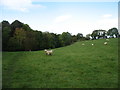
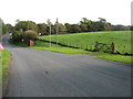
Footpath beside Row Beck, Dearham
The footpath appears to take a slightly different route from that shown on the map.
Image: © David Purchase
Taken: 13 Oct 2016
0.14 miles
4
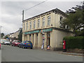
Post Office, Dearham
The post office in the village of Dearham.
Image: © Graham Robson
Taken: 17 Jun 2016
0.15 miles
5
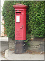
Postbox, Dearham
The pillar box located outside the village's post office.
Image: © Graham Robson
Taken: 17 Jun 2016
0.15 miles
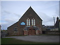
6
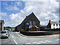
Methodist Church, Dearham
95% of this church is in NY0736
Image: © Alexander P Kapp
Taken: 5 Aug 2007
0.16 miles
9
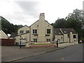
The Old Mill Inn, Dearham
One of the pubs in the Cumbrian village of Dearham.
Image: © Graham Robson
Taken: 17 Jun 2016
0.17 miles
10
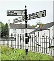
Direction Sign - Signpost on Row Brow, Dearham
Located on the south side of Row Brow. Dearham parish. 3 arms and pawn finial. Restored by Signpost Restoration.
Milestone Society National ID: CU_NY0735
Image: © B Todd
Taken: 25 Jun 2024
0.17 miles