IMAGES TAKEN NEAR TO
Cross How, MARYPORT, CA15 7JL
Introduction
This page details the photographs taken nearby to Cross How, CA15 7JL by members of the Geograph project.
The Geograph project started in 2005 with the aim of publishing, organising and preserving representative images for every square kilometre of Great Britain, Ireland and the Isle of Man.

There are currently over 7.5m images from over14,400 individuals and you can help contribute to the project by visiting https://www.geograph.org.uk
Image Map
Images are licensed for reuse under creativecommons.org/licenses/by-sa/2.0
Notes
- Clicking on the map will re-center to the selected point.
- The higher the marker number, the further away the image location is from the centre of the postcode.
Image Listing (4 Images Found)
Images are licensed for reuse under creativecommons.org/licenses/by-sa/2.0
Image
Details
Distance
2
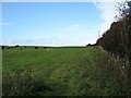
Public footpath towards the River Ellen
The footpath is rather indistinct, which suggests that it is not much used - even though it forms part of the Allerdale Ramble.
Image: © David Purchase
Taken: 13 Oct 2016
0.14 miles
3
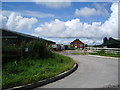
Crosshow Farm
A brand new chicken farm
Image: © Alexander P Kapp
Taken: 5 Aug 2007
0.17 miles
4

Pasture, Dearham
Sheep grazing near Crosshow Farm with Grasmoor in the background.
Image: © Andrew Smith
Taken: 28 Apr 2011
0.22 miles