IMAGES TAKEN NEAR TO
Main Street, MARYPORT, CA15 7JG
Introduction
This page details the photographs taken nearby to Main Street, CA15 7JG by members of the Geograph project.
The Geograph project started in 2005 with the aim of publishing, organising and preserving representative images for every square kilometre of Great Britain, Ireland and the Isle of Man.

There are currently over 7.5m images from over14,400 individuals and you can help contribute to the project by visiting https://www.geograph.org.uk
Image Map
Images are licensed for reuse under creativecommons.org/licenses/by-sa/2.0
Notes
- Clicking on the map will re-center to the selected point.
- The higher the marker number, the further away the image location is from the centre of the postcode.
Image Listing (19 Images Found)
Images are licensed for reuse under creativecommons.org/licenses/by-sa/2.0
Image
Details
Distance
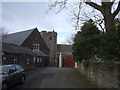
3
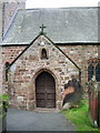
St Mungo's church, Dearham
The church hall is on the right.
Image: © David Purchase
Taken: 13 Oct 2016
0.06 miles
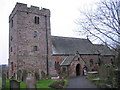
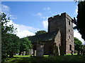
5
The entrance to St Mungo's churchyard, Dearham
Image: © John Lord
Taken: 28 Mar 2010
0.08 miles
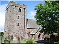
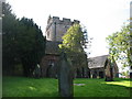
8
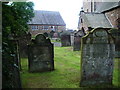
Graveyard, St Mungo's Church, Dearham
Image: © Alexander P Kapp
Taken: 5 Aug 2007
0.09 miles
9
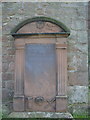
Gravestone, St Mungo's Church, Dearham
To be found leaning against the wall at the east end of the church.
Image: © Alexander P Kapp
Taken: 5 Aug 2007
0.09 miles