IMAGES TAKEN NEAR TO
Newlands Bank, MARYPORT, CA15 7HS
Introduction
This page details the photographs taken nearby to Newlands Bank, CA15 7HS by members of the Geograph project.
The Geograph project started in 2005 with the aim of publishing, organising and preserving representative images for every square kilometre of Great Britain, Ireland and the Isle of Man.

There are currently over 7.5m images from over14,400 individuals and you can help contribute to the project by visiting https://www.geograph.org.uk
Image Map
Images are licensed for reuse under creativecommons.org/licenses/by-sa/2.0
Notes
- Clicking on the map will re-center to the selected point.
- The higher the marker number, the further away the image location is from the centre of the postcode.
Image Listing (7 Images Found)
Images are licensed for reuse under creativecommons.org/licenses/by-sa/2.0
Image
Details
Distance
1
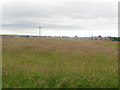
Grass field on the edge of Dearham
A grass field on the edge of Dearham. A new housing development has recently been built on the far side of the field.
Image: © Graham Robson
Taken: 17 Jun 2016
0.04 miles
2
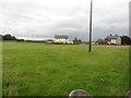
Paddock on the edge of Dearham
A grass paddock on the edge of Dearham.
Image: © Graham Robson
Taken: 17 Jun 2016
0.12 miles
3
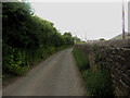
The Went, Dearham
A narrow lane close to the village of Dearham.
Image: © Graham Robson
Taken: 17 Jun 2016
0.13 miles
4
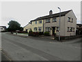
Semi detached houses, Dearham
A pair of semi detached houses on a housing estate in Dearham.
Image: © Graham Robson
Taken: 17 Jun 2016
0.16 miles
5
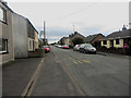
Central Road, Dearham
One of the main streets in Dearham. A roadside bus stop is in the foreground.
Image: © Graham Robson
Taken: 17 Jun 2016
0.20 miles
6
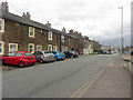
Central Road, Dearham
Looking along a long residential street in Dearham.
Image: © Graham Robson
Taken: 17 Jun 2016
0.24 miles
7
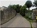
Narrow road, Dearham
A narrow road passing Dearham Primary School.
Image: © Graham Robson
Taken: 17 Jun 2016
0.25 miles