IMAGES TAKEN NEAR TO
Dearham, MARYPORT, CA15 7EX
Introduction
This page details the photographs taken nearby to CA15 7EX by members of the Geograph project.
The Geograph project started in 2005 with the aim of publishing, organising and preserving representative images for every square kilometre of Great Britain, Ireland and the Isle of Man.

There are currently over 7.5m images from over14,400 individuals and you can help contribute to the project by visiting https://www.geograph.org.uk
Image Map
Images are licensed for reuse under creativecommons.org/licenses/by-sa/2.0
Notes
- Clicking on the map will re-center to the selected point.
- The higher the marker number, the further away the image location is from the centre of the postcode.
Image Listing (15 Images Found)
Images are licensed for reuse under creativecommons.org/licenses/by-sa/2.0
Image
Details
Distance
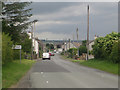
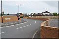
1
New houses on the edge of Dearham
Another small green area is being filled in.
Image: © Bill Boaden
Taken: 27 Aug 2019
0.10 miles
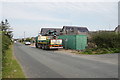
2
The west edge of Dearham
Looking along Craika Road at the west end of Dearham.
Image: © Graham Robson
Taken: 17 Jun 2016
0.11 miles
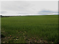
3
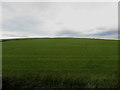
Grass field on the edge of Dearham
A grass field which has had a crop of grass recently removed on the western edge of the village of Dearham.
Image: © Graham Robson
Taken: 17 Jun 2016
0.12 miles
4
Craika Close
New housing filling in a former field.
Image: © Bill Boaden
Taken: 27 Aug 2019
0.14 miles
5
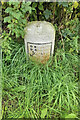
Old Milestone by the A594, south of Dearham
Metal plate attached to stone post by the A594, in parish of DEARHAM (ALLERDALE District), Dearham, South West of crossroads near 30 sign, on grass verge against wall, on South side of road. Carlisle red stone & curved plate, erected by the Cockermouth & Maryport turnpike trust in the 19th century.
Inscription reads:-
COCKERMOUTH
COURT-HOUSE
5 MILES
MARYPORT
MARKET-PLACE
2¼ MILES
Carved benchmark and rivet on top.
Grade II Listed. List Entry Number: 1144507
https://historicengland.org.uk/listing/the-list/list-entry/1144507
Milestone Society National ID: CU_CMMP05.
Image: © CF Smith
Taken: 15 Aug 2005
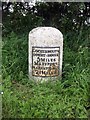
0.17 miles
6
Old Milestone by the A594, south of Dearham
Metal plate attached to stone post by the A594, in parish of DEARHAM (ALLERDALE District), Dearham, South West of crossroads near 30 sign, on grass verge against wall, on South side of road. Carlisle red stone & curved plate, erected by the Cockermouth & Maryport turnpike trust in the 19th century.
Inscription reads:-
COCKERMOUTH
COURT-HOUSE
5 MILES
MARYPORT
MARKET-PLACE
2¼ MILES
Carved benchmark and rivet on top.
Grade II Listed. List Entry Number: 1144507 https://historicengland.org.uk/listing/the-list/list-entry/1144507
Milestone Society National ID: CU_CMMP05.
Image: © Barbara Todd
Taken: 6 Sep 2023
0.17 miles
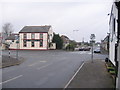
7
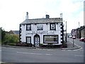
The Ploughman
One of only two pubs left in Dearham the other is The Commercial, which is on the other side of the crossroads, the third, The Globe is being converted into two houses.
Image: © Alexander P Kapp
Taken: 5 Aug 2007
0.17 miles
8
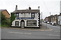
The Commercial Inn Dearham.
I am told: The pub on the right is the Ploughman, it used to be The Struggler one of only two pubs in the country with this name, the other was owned by Albert Pierpoint one of the last hangmen in Britain.
Image: © John Holmes
Taken: 20 Nov 2005
0.18 miles
9
Arable field near Craika Farm
An arable field, in which a crop of barley is growing at the time of the photograph. The field is a short distance to the west of the village of Dearham.
Image: © Graham Robson
Taken: 17 Jun 2016
0.19 miles