IMAGES TAKEN NEAR TO
Maryport Road, MARYPORT, CA15 7EG
Introduction
This page details the photographs taken nearby to Maryport Road, CA15 7EG by members of the Geograph project.
The Geograph project started in 2005 with the aim of publishing, organising and preserving representative images for every square kilometre of Great Britain, Ireland and the Isle of Man.

There are currently over 7.5m images from over14,400 individuals and you can help contribute to the project by visiting https://www.geograph.org.uk
Image Map
Images are licensed for reuse under creativecommons.org/licenses/by-sa/2.0
Notes
- Clicking on the map will re-center to the selected point.
- The higher the marker number, the further away the image location is from the centre of the postcode.
Image Listing (16 Images Found)
Images are licensed for reuse under creativecommons.org/licenses/by-sa/2.0
Image
Details
Distance
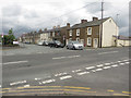
1
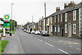
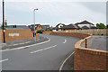
Maryport Road
Traditional ribbon development, though new housing development is now expanding the original strips.
Image: © Bill Boaden
Taken: 27 Aug 2019
0.01 miles
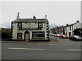
2

The Commercial, Dearham
One of only two pubs left in Dearham the other is The Ploughman, which is on the other side of the crossroads, the third, The Globe is being converted into two houses.
Image: © Alexander P Kapp
Taken: 5 Aug 2007
0.09 miles
3
The Commercial Inn Dearham.
I am told: The pub on the right is the Ploughman, it used to be The Struggler one of only two pubs in the country with this name, the other was owned by Albert Pierpoint one of the last hangmen in Britain.
Image: © John Holmes
Taken: 20 Nov 2005
0.11 miles
4
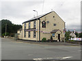
The Commercial Inn, Dearham
The Commercial Inn is a pub located at the crossroads of a pair of busy roads at the west end of Dearham. Unlike the pub across the road Image this one still is open for business.
Image: © Graham Robson
Taken: 17 Jun 2016
0.12 miles
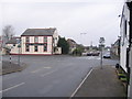
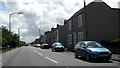
6
Central Road, Dearham
Looking across the crossroads at the western end of the village to the end of Central Road.
Image: © Graham Robson
Taken: 17 Jun 2016
0.13 miles
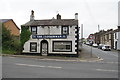
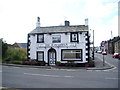
8
Former pub, Dearham
The Ploughman is a now closed pub located on a crossroads at the west end of Dearham at the junction of 2 busy roads.
Image: © Graham Robson
Taken: 17 Jun 2016
0.13 miles
9
The Ploughman
One of only two pubs left in Dearham the other is The Commercial, which is on the other side of the crossroads, the third, The Globe is being converted into two houses.
Image: © Alexander P Kapp
Taken: 5 Aug 2007
0.14 miles
10
Craika Close
New housing filling in a former field.
Image: © Bill Boaden
Taken: 27 Aug 2019
0.15 miles