IMAGES TAKEN NEAR TO
Spring Field Road, MARYPORT, CA15 7AY
Introduction
This page details the photographs taken nearby to Spring Field Road, CA15 7AY by members of the Geograph project.
The Geograph project started in 2005 with the aim of publishing, organising and preserving representative images for every square kilometre of Great Britain, Ireland and the Isle of Man.

There are currently over 7.5m images from over14,400 individuals and you can help contribute to the project by visiting https://www.geograph.org.uk
Image Map
Images are licensed for reuse under creativecommons.org/licenses/by-sa/2.0
Notes
- Clicking on the map will re-center to the selected point.
- The higher the marker number, the further away the image location is from the centre of the postcode.
Image Listing (27 Images Found)
Images are licensed for reuse under creativecommons.org/licenses/by-sa/2.0
Image
Details
Distance
1
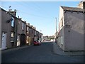
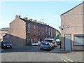
Western end, Ellenborough Old Road
By the junction with Ada Street.
Image: © Christine Johnstone
Taken: 28 Feb 2013
0.09 miles
3
Junction of Ellenborough Old Road and Shaw Street
Image: © Roger Templeman
Taken: 27 Jun 2012
0.09 miles
4
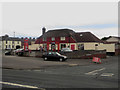
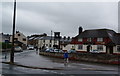
One Stop convenience store, Maryport
A One Stop convenience store in a building which has been converted from a pub. Pictured in Image the pub was trading as the Bounty Inn.
Image: © Graham Robson
Taken: 17 Jun 2016
0.10 miles
5
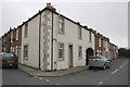
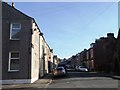
Argyle Terrace, Ellenborough Old Road
North-west of the junction with Elizabeth Street.
Image: © Christine Johnstone
Taken: 28 Feb 2013
0.10 miles

7
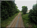
Railway line, Maryport
Looking north east from the road bridge which crosses the Cumbrian Coast Line in Maryport.
Image: © Graham Robson
Taken: 17 Jun 2016
0.11 miles
8
Ellenborough Road railway bridge
There is an OS benchmark Image on the middle of the bridge parapet over the centre of the railway tracks
Image: © Roger Templeman
Taken: 27 Jun 2012
0.11 miles
9
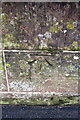
Benchmark on railway bridge, Ellenborough Road
Ordnance Survey cut mark benchmark described on the Bench Mark Database at http://www.bench-marks.org.uk/bm43696
Image: © Roger Templeman
Taken: 27 Jun 2012
0.11 miles
10
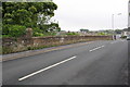
Ellenborough Old Road, Netherton
South-west of, and parallel to, the current Ellenborough Road [A594].
Image: © Christine Johnstone
Taken: 28 Feb 2013
0.12 miles