IMAGES TAKEN NEAR TO
Bullgill, MARYPORT, CA15 6TW
Introduction
This page details the photographs taken nearby to CA15 6TW by members of the Geograph project.
The Geograph project started in 2005 with the aim of publishing, organising and preserving representative images for every square kilometre of Great Britain, Ireland and the Isle of Man.

There are currently over 7.5m images from over14,400 individuals and you can help contribute to the project by visiting https://www.geograph.org.uk
Image Map
Images are licensed for reuse under creativecommons.org/licenses/by-sa/2.0
Notes
- Clicking on the map will re-center to the selected point.
- The higher the marker number, the further away the image location is from the centre of the postcode.
Image Listing (12 Images Found)
Images are licensed for reuse under creativecommons.org/licenses/by-sa/2.0
Image
Details
Distance
1
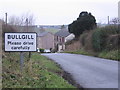
Bullgill.
There are many ways of spelling gill but most mean a valley where there is a water course like a stream or beck.
Image: © John Holmes
Taken: 9 Dec 2005
0.07 miles
2
Down the line at sunset.
I hope the horses are used to the trains being so close to the line.
Image: © John Holmes
Taken: 1 Jan 2006
0.07 miles
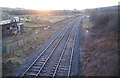
3
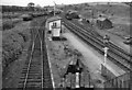
Bulgill railway station (site), Cumbria
Opened in 1845 by the Maryport & Carlisle Railway on what is today the line from Barrow-in-Furness to Carlisle, this station closed to passengers in 1960 and completely in 1964.
View north east towards Aspatria and Carlisle. The Carlisle-bound platform and main building were to the left of the line on this side of the bridge. The Maryport-bound platform was on the other side of the bridge, behind the camera position.
Image: © Nigel Thompson
Taken: 14 Jul 2013
0.14 miles
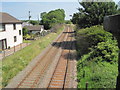
4
Bulgill railway station (site), Cumbria
Opened in 1845 by the Maryport & Carlisle Railway on what is today the line from Barrow-in-Furness to Carlisle, this station closed to passengers in 1960 and completely in 1964.
View south west towards Dearham Bridge, Maryport and Barrow. The Maryport-bound platform was to the left of the line on this side of the bridge. The Carlisle-bound platform and main building were on the other side of the bridge, behind the camera position. The steps down to platform level can still be seen on the left.
Image: © Nigel Thompson
Taken: 14 Jul 2013
0.14 miles
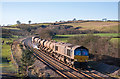
5
Trains at Bullgill, Cumbria - November 2017 (1)
Diesel unit 153301 approaches the site of Bullgill station with the 09.20 passenger service from Barrow-in-Furness to Carlisle.
For a 1961 view of this location, see: Image] .
Image: © The Carlisle Kid
Taken: 30 Nov 2017
0.14 miles
6
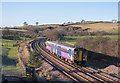
Trains at Bullgill, Cumbria - November 2017 (2)
EWS liveried diesel locomotive 66162 approaches the site of Bullgill station with train 6C48, the 11.11 Workington Docks - Carlisle North Yard kaolin tanks.
For a 1961 view of this location, see: Image] .
Image: © The Carlisle Kid
Taken: 30 Nov 2017
0.14 miles
7
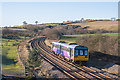
Trains at Bullgill, Cumbria - November 2017 (3)
Diesel unit 142027 approaches the site of Bullgill station with the 10.10 passenger service from Barrow-in-Furness to Carlisle.
For a 1961 view at this location, see: Image] .
Image: © The Carlisle Kid
Taken: 30 Nov 2017
0.14 miles
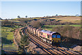
8
Trains at Bullgill, Cumbria - November 2017 (4)
Utterly filthy DRS liveried diesel locomotives 66422 & 66423 "top and tail" the Network Rail Railhead Treatment Train as it heads for Carlisle past the site of Bullgill station.
For a 1961 view of this location, see: Image] .
Image: © The Carlisle Kid
Taken: 30 Nov 2017
0.14 miles
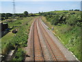
9
Bullgill Station (remains)
View SW, towards Maryport and junction with its Derwent Valley branch to Brigham; ex-Maryport & Carlisle main line from Carlisle. Bullgill station was closed to passengers on 7/3/60, goods on 2/3/64, the branch to Brigham having closed in 4/35.
Image: © Ben Brooksbank
Taken: 25 Sep 1961
0.14 miles
10
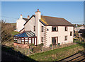
Former Bullgill station building - November 2017
Old OS Maps show that Bullgill station had staggered platforms, this building serving Carlisle bound trains. The station closed to passengers on 7 March 1960 and this building has been much altered since.
For a 1961 view of the Maryport bound platform, see: Image] .
Image: © The Carlisle Kid
Taken: 30 Nov 2017
0.14 miles