IMAGES TAKEN NEAR TO
Old Road, MARYPORT, CA15 6SU
Introduction
This page details the photographs taken nearby to Old Road, CA15 6SU by members of the Geograph project.
The Geograph project started in 2005 with the aim of publishing, organising and preserving representative images for every square kilometre of Great Britain, Ireland and the Isle of Man.

There are currently over 7.5m images from over14,400 individuals and you can help contribute to the project by visiting https://www.geograph.org.uk
Image Map
Images are licensed for reuse under creativecommons.org/licenses/by-sa/2.0
Notes
- Clicking on the map will re-center to the selected point.
- The higher the marker number, the further away the image location is from the centre of the postcode.
Image Listing (4 Images Found)
Images are licensed for reuse under creativecommons.org/licenses/by-sa/2.0
Image
Details
Distance
2

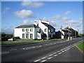
The Stag Inn, Crosby, Cumbria - June 2017
Late 19th Century Inn on the main road from Maryport to Aspatria.
Photograph is for record only - I have no connection with this business and cannot advise on its products or services.
Image: © The Carlisle Kid
Taken: 19 Jun 2017
0.10 miles
3

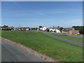
The A596(T) at Crosby
The village of Crosby is cut in two by the A595(T) just NE of Maryport.
Image: © Nigel Monckton
Taken: 29 Aug 2005
0.17 miles