IMAGES TAKEN NEAR TO
Camp Side, MARYPORT, CA15 6NX
Introduction
This page details the photographs taken nearby to Camp Side, CA15 6NX by members of the Geograph project.
The Geograph project started in 2005 with the aim of publishing, organising and preserving representative images for every square kilometre of Great Britain, Ireland and the Isle of Man.

There are currently over 7.5m images from over14,400 individuals and you can help contribute to the project by visiting https://www.geograph.org.uk
Image Map
Images are licensed for reuse under creativecommons.org/licenses/by-sa/2.0
Notes
- Clicking on the map will re-center to the selected point.
- The higher the marker number, the further away the image location is from the centre of the postcode.
Image Listing (17 Images Found)
Images are licensed for reuse under creativecommons.org/licenses/by-sa/2.0
Image
Details
Distance
1
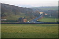
Road Junction
B5300 left to Allonby, A596T forward right to Crosby and back right to Maryport.
Image: © Bob Jenkins
Taken: 8 Dec 2005
0.10 miles
2
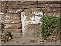
Old Milestone by the A596, north east of Maryport
Stone post by the A596 (Metal plate missing), in parish of MARYPORT (ALLERDALE District), Netherhall, South of B5300 junction, in wall and tarmac; opposite LPE289, on West side of road. Wigton curved red stone, erected by the Cockermouth & Maryport turnpike trust in the 19th century.
Inscription once read:-
(WORKINGTON)
(7)
(WIGTON)
(16)
Carved benchmark on top.
Milestone Society National ID: CU_WGWO16
Image: © CF Smith
Taken: 16 Sep 2005
0.13 miles
3
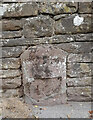
Old Milestone by the A596, north east of Maryport
Stone post by the A596 (Metal plate missing), in parish of MARYPORT (ALLERDALE District), Netherhall, South of B5300 junction, in wall and tarmac; opposite LPE289, on West side of road. Wigton curved red stone, erected by the Cockermouth & Maryport turnpike trust in the 19th century.
Inscription once read:-
(WORKINGTON)
(7)
(WIGTON)
(16)
Carved benchmark on top.
Milestone Society National ID: CU_WGWO16
Image: © Barbara Todd
Taken: 7 Sep 2023
0.13 miles
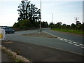
5
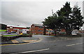
The entrance to Netherhall Sports Centre
Netherhall School is to the right.
Image: © Bill Boaden
Taken: 19 Jul 2010
0.15 miles
6
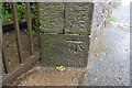
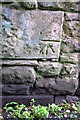
Benchmark on wall end at SE end of Pigeonwell Lonning
Ordnance Survey cut mark benchmark described on the Bench Mark Database at http://www.bench-marks.org.uk/bm43778
Image: © Roger Templeman
Taken: 27 Jun 2012
0.16 miles
7
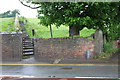
The steps of Pigeonwell Lonning at A596 entrance
There is an OS benchmark Image on the inside face of the wall end at the right hand side of the entrance
Image: © Roger Templeman
Taken: 27 Jun 2012
0.16 miles
8
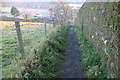
Path to Netherhall School
Narrow and steep path runs straight up a moraine
Image: © Bob Jenkins
Taken: 8 Dec 2005
0.18 miles
9
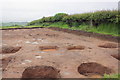
Archaeological dig site by Camp Farm trig point
Ongoing excavations near the Roman Fort. The trig pillar in the hedge is described in detail at http://www.trigpointinguk.com/trigs/trig-details.php?t=1887
Image: © Roger Templeman
Taken: 27 Jun 2012
0.18 miles
10
Benchmark on wall of Pigeonwell Lonning
Ordnance Survey cut mark benchmark described on the Bench Mark Database at http://www.bench-marks.org.uk/bm43777
Image: © Roger Templeman
Taken: 27 Jun 2012
0.18 miles