IMAGES TAKEN NEAR TO
Netherhall Road, MARYPORT, CA15 6NT
Introduction
This page details the photographs taken nearby to Netherhall Road, CA15 6NT by members of the Geograph project.
The Geograph project started in 2005 with the aim of publishing, organising and preserving representative images for every square kilometre of Great Britain, Ireland and the Isle of Man.

There are currently over 7.5m images from over14,400 individuals and you can help contribute to the project by visiting https://www.geograph.org.uk
Image Map
Images are licensed for reuse under creativecommons.org/licenses/by-sa/2.0
Notes
- Clicking on the map will re-center to the selected point.
- The higher the marker number, the further away the image location is from the centre of the postcode.
Image Listing (13 Images Found)
Images are licensed for reuse under creativecommons.org/licenses/by-sa/2.0
Image
Details
Distance
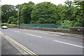
2
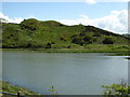
Ancient earthworks by the river in Maryport
Image: © Sarah Charlesworth
Taken: 22 May 2016
0.15 miles
3
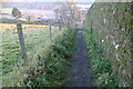
Path to Netherhall School
Narrow and steep path runs straight up a moraine
Image: © Bob Jenkins
Taken: 8 Dec 2005
0.16 miles
4
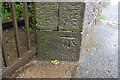
Benchmark on wall end at SE end of Pigeonwell Lonning
Ordnance Survey cut mark benchmark described on the Bench Mark Database at http://www.bench-marks.org.uk/bm43778
Image: © Roger Templeman
Taken: 27 Jun 2012
0.19 miles
5
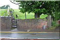
The steps of Pigeonwell Lonning at A596 entrance
There is an OS benchmark Image on the inside face of the wall end at the right hand side of the entrance
Image: © Roger Templeman
Taken: 27 Jun 2012
0.19 miles
6
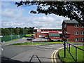
Netherhall Sports Centre
The sports centre is part of Netherhall School but is open for public use
Image: © Alexander P Kapp
Taken: 5 Aug 2007
0.21 miles
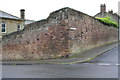
7
Benchmark on Church Street wall at North Street junction
Ordnance Survey cut mark benchmark described on the Bench Mark Database at http://www.bench-marks.org.uk/bm43774
Image: © Roger Templeman
Taken: 27 Jun 2012
0.23 miles
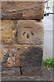
8
Ordnance Survey Cut Mark
This OS cut mark can be found on the junction of Church Street & North Street. It marks a point 34.250m above mean sea level.
Image: © Adrian Dust
Taken: 27 Mar 2018
0.23 miles
9
Ellen Bridge
The bridge takes the A594 (Ellenborough Road) over the River Ellen. There is an OS benchmark Image at the centre of the parapet
Image: © Roger Templeman
Taken: 27 Jun 2012
0.24 miles
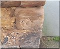
10
Junction of Church Street and North Street
There is an OS benchmark Image on a corner stone of the wall, on its Church Street face
Image: © Roger Templeman
Taken: 27 Jun 2012
0.24 miles