IMAGES TAKEN NEAR TO
Mealpot Road, MARYPORT, CA15 6NQ
Introduction
This page details the photographs taken nearby to Mealpot Road, CA15 6NQ by members of the Geograph project.
The Geograph project started in 2005 with the aim of publishing, organising and preserving representative images for every square kilometre of Great Britain, Ireland and the Isle of Man.

There are currently over 7.5m images from over14,400 individuals and you can help contribute to the project by visiting https://www.geograph.org.uk
Image Map
Images are licensed for reuse under creativecommons.org/licenses/by-sa/2.0
Notes
- Clicking on the map will re-center to the selected point.
- The higher the marker number, the further away the image location is from the centre of the postcode.
Image Listing (91 Images Found)
Images are licensed for reuse under creativecommons.org/licenses/by-sa/2.0
Image
Details
Distance
1
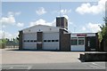
Maryport fire station
Maryport fire station, Mealpot Road, Maryport, Cumbria, showing an updated view from Image
Image: © Kevin Hale
Taken: 28 May 2010
0.00 miles
2
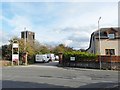
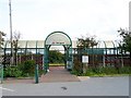
Approach to Maryport Station
View from the end of Station Street across Mealpot Road. The railway station http://www.geograph.org.uk/photo/2125868 is down the drive past the parked vans.
The stone gateposts and wall are about all that remains of the impressive original station - see picture taken c.1904 http://myweb.tiscali.co.uk/hstchg/railway23.jpg .
The tower on the left is at Image .
Image: © Rose and Trev Clough
Taken: 30 Sep 2010
0.02 miles
4
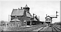
Maryport Station
View NE, towards Carlisle; ex-Maryport & Carlisle Rly. secondary main line from Carlisle and on (ex-LNWR) to Workington. Note that the station had only a single platform, for Down as well as Up trains.
Image: © Walter Dendy -- deceased
Taken: 2 Jun 1951
0.03 miles
5
Maryport Railway Station
An unmanned station with a waiting shelter and a bike shed. There is only one platform here, which is on the opposite side of the track to where the majority of Maryport's population now live http://www.timesandstar.co.uk/news/other/no-second-platform-for-maryport-train-station-1.759032?referrerPath=/t_s_news_feed_1_17079 .
The station is a shadow of its former self - for a photo taken in 1951, see Image .
Image: © Rose and Trev Clough
Taken: 30 Sep 2010
0.04 miles
6
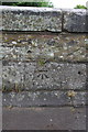
Benchmark on Station Street bridge
Ordnance Survey cut mark benchmark described on the Bench Mark Database at http://www.bench-marks.org.uk/bm43746
Image: © Roger Templeman
Taken: 21 Jun 2012
0.04 miles
7

Ordnance Survey Cut Mark
This OS cut mark can be found on the NE parapet of the bridge. It marks a point 7.741m above mean sea level.
Image: © Adrian Dust
Taken: 27 Mar 2018
0.04 miles
8
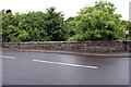
Station Street bridge over River Ellen
There is an OS benchmark Image on the middle of the parapet
Image: © Roger Templeman
Taken: 21 Jun 2012
0.04 miles
9
Maryport station with train, 1974
View NE, towards Carlisle: ex-Maryport & Carlisle main line, with end-on junction with the ex-LNWR Cumbrian Coast line to Workington and Whitehaven. (Cf. Image, when the station had some buildings!).
Image: © Walter Dendy, deceased
Taken: 1 Aug 1974
0.05 miles
10
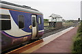
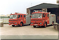
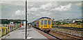
A Carlisle-bound train and signal box at Maryport station
The diesel multiple unit forming the Northern service is Super Sprinter Class 156 number 156448.
Image: © Roger Templeman
Taken: 21 Jun 2012
0.06 miles