IMAGES TAKEN NEAR TO
Station Street, MARYPORT, CA15 6LT
Introduction
This page details the photographs taken nearby to Station Street, CA15 6LT by members of the Geograph project.
The Geograph project started in 2005 with the aim of publishing, organising and preserving representative images for every square kilometre of Great Britain, Ireland and the Isle of Man.

There are currently over 7.5m images from over14,400 individuals and you can help contribute to the project by visiting https://www.geograph.org.uk
Image Map
Images are licensed for reuse under creativecommons.org/licenses/by-sa/2.0
Notes
- Clicking on the map will re-center to the selected point.
- The higher the marker number, the further away the image location is from the centre of the postcode.
Image Listing (114 Images Found)
Images are licensed for reuse under creativecommons.org/licenses/by-sa/2.0
Image
Details
Distance
1
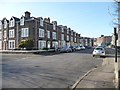
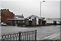
Three-storey houses in Station Street, Maryport
Between the railway station and the town centre.
Image: © Christine Johnstone
Taken: 28 Feb 2013
0.02 miles
2
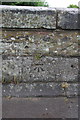
Benchmark on Station Street bridge
Ordnance Survey cut mark benchmark described on the Bench Mark Database at http://www.bench-marks.org.uk/bm43746
Image: © Roger Templeman
Taken: 21 Jun 2012
0.02 miles
3
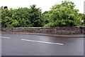
Station Street bridge over River Ellen
There is an OS benchmark Image on the middle of the parapet
Image: © Roger Templeman
Taken: 21 Jun 2012
0.02 miles
4

Ordnance Survey Cut Mark
This OS cut mark can be found on the NE parapet of the bridge. It marks a point 7.741m above mean sea level.
Image: © Adrian Dust
Taken: 27 Mar 2018
0.02 miles
5
Trinity Baptist Church
On the corner of Station Street and Curzon Street.
Image: © Bill Boaden
Taken: 19 Jul 2010
0.03 miles
6
Waverley Hotel, Maryport - June 2017
Late 19th Century hotel on the corner of Station Street and Curzon Street.
Photograph is for record only - I have no connection with this business and cannot advise on its products or services.
Image: © The Carlisle Kid
Taken: 19 Jun 2017
0.04 miles
7
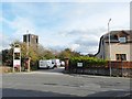
Approach to Maryport Station
View from the end of Station Street across Mealpot Road. The railway station http://www.geograph.org.uk/photo/2125868 is down the drive past the parked vans.
The stone gateposts and wall are about all that remains of the impressive original station - see picture taken c.1904 http://myweb.tiscali.co.uk/hstchg/railway23.jpg .
The tower on the left is at Image .
Image: © Rose and Trev Clough
Taken: 30 Sep 2010
0.04 miles
8

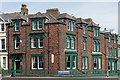
Town houses at Maryport
Impressive buildings in the Cumbrian seaside town.
Image: © James Denham
Taken: 3 Jul 2010
0.05 miles
9
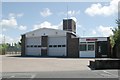
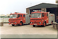
Maryport fire station
Maryport fire station, Mealpot Road, Maryport, Cumbria, showing an updated view from Image
Image: © Kevin Hale
Taken: 28 May 2010
0.05 miles