IMAGES TAKEN NEAR TO
Crosby Street, MARYPORT, CA15 6JX
Introduction
This page details the photographs taken nearby to Crosby Street, CA15 6JX by members of the Geograph project.
The Geograph project started in 2005 with the aim of publishing, organising and preserving representative images for every square kilometre of Great Britain, Ireland and the Isle of Man.

There are currently over 7.5m images from over14,400 individuals and you can help contribute to the project by visiting https://www.geograph.org.uk
Image Map
Images are licensed for reuse under creativecommons.org/licenses/by-sa/2.0
Notes
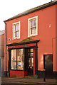
- Clicking on the map will re-center to the selected point.
- The higher the marker number, the further away the image location is from the centre of the postcode.
Image Listing (232 Images Found)
Images are licensed for reuse under creativecommons.org/licenses/by-sa/2.0
Image
Details
Distance
1
Former "Sun Inn", Wood Street, Maryport - October 2017
First appears in the 1811 "Cumberland Guide & Directory", the "Sun Inn" was acquired by the State Management Scheme in November 1918. No record has been found of its sale, but it appears on the 1970 OS Map.
Now the premises of MANA Credit Union.
Photograph is for record only - I have no connection with MANA Credit Union and cannot advise on their products or services.
Image: © The Carlisle Kid
Taken: 27 Oct 2017
0.01 miles
2
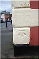
Benchmark on #51 Wood Street
Ordnance Survey cut mark benchmark described on the Bench Mark Database at http://www.bench-marks.org.uk/bm43744
Image: © Roger Templeman
Taken: 21 Jun 2012
0.01 miles
3
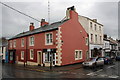
#51 Wood Street at Crosby Street junction
Formerly the Sun Inn, now the premises on a monumental mason. There is an OS benchmark Image on a corner stone on the Crosby Street face
Image: © Roger Templeman
Taken: 21 Jun 2012
0.01 miles
4
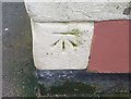
Ordnance Survey Cut Mark
This OS cut mark can be found on No51 Wood Street. It marks a point 17.998m above mean sea level.
Image: © Adrian Dust
Taken: 27 Mar 2018
0.01 miles
5
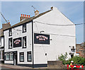
Butchers Arms, Crosby Street, Maryport - June 2017
Early 19th Century pub first mentioned in Slaters Directory of 1848. Still trading.
Photograph is for record only - I have no connection with this business and cannot advise on its products or services.
Image: © The Carlisle Kid
Taken: 19 Jun 2017
0.02 miles
6
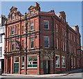
Former "Victoria Hotel", Crosby Street, Maryport - June 2017 (1)
Renamed "Royal Victoria" during the State Management era, these substantial premises date from circa 1850 and are first mentioned in Slater's Directory of 1855.
Acquired by the State Management Scheme in November 1918, it was sold to John Smiths Brewing Group on 9 May 1973. Still trading.
Photograph is for record only - I have no connection with this business and cannot advise on its products or services.
Image: © The Carlisle Kid
Taken: 19 Jun 2017
0.02 miles
8
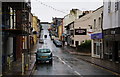
Crosby Street, Maryport
Looking north along Crosby Street, Maryport, with a police car in the foreground.
Image: © Graham Robson
Taken: 14 Jul 2012
0.03 miles
9
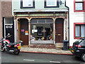
Shop front, Wood Street, Maryport
Until recently 48 Wood Street was home to a shoe shop. Since its close the shop front has been stripped back to reveal an earlier (Victorian?) incarnation.
Image: © Jim Osley
Taken: 28 Jun 2013
0.03 miles
10
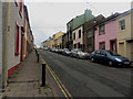
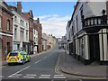
Wood Street, Maryport
A residential street close to the centre of Maryport.
Image: © Graham Robson
Taken: 17 Jun 2016
0.04 miles