IMAGES TAKEN NEAR TO
John Street, MARYPORT, CA15 6JT
Introduction
This page details the photographs taken nearby to John Street, CA15 6JT by members of the Geograph project.
The Geograph project started in 2005 with the aim of publishing, organising and preserving representative images for every square kilometre of Great Britain, Ireland and the Isle of Man.

There are currently over 7.5m images from over14,400 individuals and you can help contribute to the project by visiting https://www.geograph.org.uk
Image Map
Images are licensed for reuse under creativecommons.org/licenses/by-sa/2.0
Notes
- Clicking on the map will re-center to the selected point.
- The higher the marker number, the further away the image location is from the centre of the postcode.
Image Listing (267 Images Found)
Images are licensed for reuse under creativecommons.org/licenses/by-sa/2.0
Image
Details
Distance
1
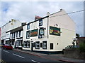
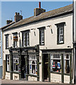
The Butchers Arms, High Street, Maryport
Image: © Alexander P Kapp
Taken: 5 Aug 2007
0.02 miles
2
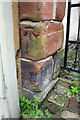
Benchmark on gate post next to #76 High Street
Ordnance Survey cut mark benchmark desscibed on the Bench Mark Database at http://www.bench-marks.org.uk/bm43417
Image: © Roger Templeman
Taken: 27 Jun 2012
0.02 miles
3
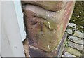
Ordnance Survey Cut Mark
This OS cut mark can be found on No76 High Street. It marks a point 20.102m above mean sea level.
Image: © Adrian Dust
Taken: 27 Mar 2018
0.02 miles
4
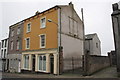
#76 High Street
There is an OS benchmark Image on the gatepost abutting the house
Image: © Roger Templeman
Taken: 27 Jun 2012
0.03 miles
5
Former "Broom Vaults", High Street, Maryport - June 2017
Early 19th Century pub, also known as the "Top Tap" and currently the "Phoenix Tap". First recorded in the Cumberland Census of 1861, it was acquired by the State Management Scheme in October 1918. Sold to John Smiths Brewery Group on 1 May 1973, it has suffered recent periods of closure - but is currently trading.
A 2012 view may be seen: http://pubshistory.com/Cumberland/Maryport/BroomVaults.shtml
Photograph is for record only - I have no connection with this business and cannot advise on its products or services.
Image: © The Carlisle Kid
Taken: 19 Jun 2017
0.03 miles
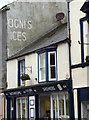
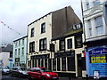
7
The White Star, Senhouse Street, Maryport
Image: © Alexander P Kapp
Taken: 5 Aug 2007
0.03 miles
8
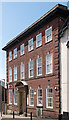
Maryport Post Office - June 2017
Situated on High Street and early 20th Century, a Post Office first appears on this site on the 1925 OS Map.
Image: © The Carlisle Kid
Taken: 19 Jun 2017
0.03 miles
9
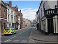
Crosby Street, Maryport
Looking north along Crosby Street, Maryport, with a police car in the foreground.
Image: © Graham Robson
Taken: 14 Jul 2012
0.03 miles
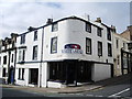
10
The Crown Inn, Senhouse Street, Maryport
Image: © Alexander P Kapp
Taken: 5 Aug 2007
0.03 miles