IMAGES TAKEN NEAR TO
Camp Road, MARYPORT, CA15 6JN
Introduction
This page details the photographs taken nearby to Camp Road, CA15 6JN by members of the Geograph project.
The Geograph project started in 2005 with the aim of publishing, organising and preserving representative images for every square kilometre of Great Britain, Ireland and the Isle of Man.

There are currently over 7.5m images from over14,400 individuals and you can help contribute to the project by visiting https://www.geograph.org.uk
Image Map
Images are licensed for reuse under creativecommons.org/licenses/by-sa/2.0
Notes
- Clicking on the map will re-center to the selected point.
- The higher the marker number, the further away the image location is from the centre of the postcode.
Image Listing (54 Images Found)
Images are licensed for reuse under creativecommons.org/licenses/by-sa/2.0
Image
Details
Distance
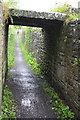
1
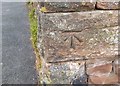
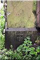
Ordnance Survey Cut Mark
This OS cut mark can be found on the wall NW side of Camp Road. It marks a point 49.091m above mean sea level.
Image: © Adrian Dust
Taken: 27 Mar 2018
0.05 miles
2
Wall of the Roman Fort at Camp Road/footpath junction
There is an OS benchmark Image on a corner stone of the wall left of the footpath fingerpost pointing towards the coast.
Image: © Roger Templeman
Taken: 27 Jun 2012
0.05 miles
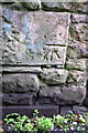
3
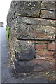
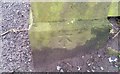
Benchmark on the Camp Road corner of the Roman Fort
Ordnance Survey cut mark benchmark described on the Bench Mark Database at http://www.bench-marks.org.uk/bm43779
Image: © Roger Templeman
Taken: 27 Jun 2012
0.05 miles
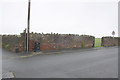
4
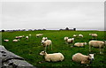
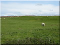
Sheep grazing on Alavna
This is the site of the Roman fort Alavna. There isn't much to see apart from raised land, but it appeared to cover a large area.
Image: © Bill Boaden
Taken: 19 Jul 2010
0.06 miles
5
Benchmark on gatepost of North Grove House
Ordnance Survey cut mark benchmark described on the Bench Mark Database at http://www.bench-marks.org.uk/bm43776
Image: © Roger Templeman
Taken: 27 Jun 2012
0.09 miles
6
Ordnance Survey Cut Mark
This OS cut mark can be found on a gatepost at the side entrance to North Grove House. It marks a point 55.617m above mean sea level.
Image: © Adrian Dust
Taken: 27 Mar 2018
0.09 miles
7
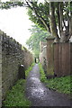
Looking along Pigeonwell Lonning from North Grove House
There is an OS benchmark Image on the gatepost on the right hand side of the path
Image: © Roger Templeman
Taken: 27 Jun 2012
0.09 miles
8
Site of the Roman fort at Maryport
Image: © Sarah Charlesworth
Taken: 22 May 2016
0.11 miles
9
Pigeonwell Lonning
There is an OS benchmark Image on the wall near the right hand side of the image
Image: © Roger Templeman
Taken: 27 Jun 2012
0.11 miles
10
Benchmark on wall of Pigeonwell Lonning
Ordnance Survey cut mark benchmark described on the Bench Mark Database at http://www.bench-marks.org.uk/bm43777
Image: © Roger Templeman
Taken: 27 Jun 2012
0.13 miles