IMAGES TAKEN NEAR TO
The Promenade, MARYPORT, CA15 6JD
Introduction
This page details the photographs taken nearby to The Promenade, CA15 6JD by members of the Geograph project.
The Geograph project started in 2005 with the aim of publishing, organising and preserving representative images for every square kilometre of Great Britain, Ireland and the Isle of Man.

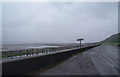
There are currently over 7.5m images from over14,400 individuals and you can help contribute to the project by visiting https://www.geograph.org.uk
Image Map
Images are licensed for reuse under creativecommons.org/licenses/by-sa/2.0
Notes
- Clicking on the map will re-center to the selected point.
- The higher the marker number, the further away the image location is from the centre of the postcode.
Image Listing (81 Images Found)
Images are licensed for reuse under creativecommons.org/licenses/by-sa/2.0
Image
Details
Distance
1
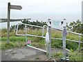
Top of the Fairy Path
Leading from the Upper to the Lower Promenade.
Image: © Oliver Dixon
Taken: 10 Sep 2021
0.03 miles
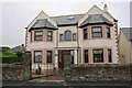
2
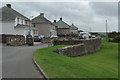
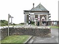
The Promenade, Maryport
These semi-detached houses enjoy a spectacular sea view. They are seen here from the entrance to the Senhouse Museum.
Image: © Stephen McKay
Taken: 5 Oct 2014
0.06 miles
3
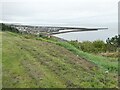
View from the upper Promenade
A good view of Maryport Harbour.
Image: © Oliver Dixon
Taken: 10 Sep 2021
0.06 miles
4
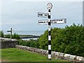
Direction sign at Alauna, Maryport
Alauna was the name of a fort established here by the Romans around AD122. There is a museum of Roman remains nearby, hence the unusual inclusion of Rome in the directions.
Image: © Graham Hogg
Taken: 13 Jul 2019
0.08 miles
5
No reason to be on the promenade today
A damp grey day, but there were still people out on the beach.
Image: © Bill Boaden
Taken: 19 Jul 2010
0.08 miles
6
Senhouse Museum
Housing a collection of Roman remains found nearby, including a large selection of Roman altars. Note the signpost!
Image: © Oliver Dixon
Taken: 10 Sep 2021
0.09 miles
7
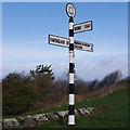
Finger post, Maryport
Outside Senhouse Roman Museum. Alauna is the name of the Roman fort here. The distance to Rome (1846 km) is direct, not by road.
Image: © Ian Taylor
Taken: 15 Mar 2019
0.09 miles
8
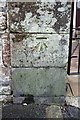
Benchmark on gatepost of house on The Promenade
Ordnance Survey cut mark benchmark described on the Bench Mark Database at http://www.bench-marks.org.uk/bm43783
Image: © Roger Templeman
Taken: 27 Jun 2012
0.09 miles
9
'Firth House 2000', The Promenade
There is an OS benchmark Image on the left hand gatepost of the entrance to the house
Image: © Roger Templeman
Taken: 27 Jun 2012
0.09 miles
10
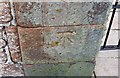
Ordnance Survey Cut Mark
This OS cut mark can be found on the gatepost of Firth House. It marks a point 39.220m above mean sea level.
Image: © Adrian Dust
Taken: 27 Mar 2018
0.09 miles