IMAGES TAKEN NEAR TO
Church Street, MARYPORT, CA15 6HA
Introduction
This page details the photographs taken nearby to Church Street, CA15 6HA by members of the Geograph project.
The Geograph project started in 2005 with the aim of publishing, organising and preserving representative images for every square kilometre of Great Britain, Ireland and the Isle of Man.

There are currently over 7.5m images from over14,400 individuals and you can help contribute to the project by visiting https://www.geograph.org.uk
Image Map
Images are licensed for reuse under creativecommons.org/licenses/by-sa/2.0
Notes
- Clicking on the map will re-center to the selected point.
- The higher the marker number, the further away the image location is from the centre of the postcode.
Image Listing (188 Images Found)
Images are licensed for reuse under creativecommons.org/licenses/by-sa/2.0
Image
Details
Distance
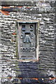
1
Benchmark on gatepost at St Mary's Church entrance
Ordnance Survey cut mark benchmark described on the Bench Mark Database at http://www.bench-marks.org.uk/bm43581
Image: © Roger Templeman
Taken: 21 Jun 2012
0.01 miles
2
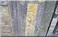
Ordnance Survey Cut Mark
This OS cut mark can be found on the gatepost of St Mary's Church. It marks a point 15.133m above mean sea level.
Image: © Adrian Dust
Taken: 27 Mar 2018
0.01 miles
3
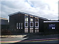
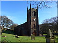
St Mark's Methodist Church, Maryport
Image: © Alexander P Kapp
Taken: 5 Aug 2007
0.02 miles
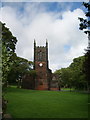
4
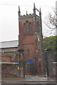
St Mary's Church through the Church Street entrance
There is an OS benchmark Image on the left hand gatepost which appears to carry a fire hydrant indicator
Image: © Roger Templeman
Taken: 21 Jun 2012
0.02 miles
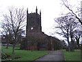
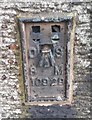
6
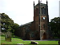
Benchmark on St Mary's Church
Ordnance Survey flush bracket serial number 10929 benchmark described on the Bench Mark Database at http://www.bench-marks.org.uk/bm11406
Image: © Roger Templeman
Taken: 21 Jun 2012
0.03 miles
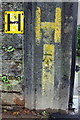
7
Ordnance Survey Flush Bracket (10929)
This OS Flush Bracket can be found on the south angle of St Mary's Church. It marks a point 11.037m above mean sea level.
Image: © Adrian Dust
Taken: 27 Mar 2018
0.03 miles