IMAGES TAKEN NEAR TO
High Street, MARYPORT, CA15 6BG
Introduction
This page details the photographs taken nearby to High Street, CA15 6BG by members of the Geograph project.
The Geograph project started in 2005 with the aim of publishing, organising and preserving representative images for every square kilometre of Great Britain, Ireland and the Isle of Man.

There are currently over 7.5m images from over14,400 individuals and you can help contribute to the project by visiting https://www.geograph.org.uk
Image Map
Images are licensed for reuse under creativecommons.org/licenses/by-sa/2.0
Notes
- Clicking on the map will re-center to the selected point.
- The higher the marker number, the further away the image location is from the centre of the postcode.
Image Listing (277 Images Found)
Images are licensed for reuse under creativecommons.org/licenses/by-sa/2.0
Image
Details
Distance
1
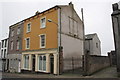
#76 High Street
There is an OS benchmark Image on the gatepost abutting the house
Image: © Roger Templeman
Taken: 27 Jun 2012
0.00 miles
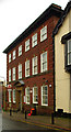
2
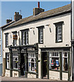
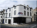
Former "Broom Vaults", High Street, Maryport - June 2017
Early 19th Century pub, also known as the "Top Tap" and currently the "Phoenix Tap". First recorded in the Cumberland Census of 1861, it was acquired by the State Management Scheme in October 1918. Sold to John Smiths Brewery Group on 1 May 1973, it has suffered recent periods of closure - but is currently trading.
A 2012 view may be seen: http://pubshistory.com/Cumberland/Maryport/BroomVaults.shtml
Photograph is for record only - I have no connection with this business and cannot advise on its products or services.
Image: © The Carlisle Kid
Taken: 19 Jun 2017
0.01 miles
3
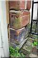
Benchmark on gate post next to #76 High Street
Ordnance Survey cut mark benchmark desscibed on the Bench Mark Database at http://www.bench-marks.org.uk/bm43417
Image: © Roger Templeman
Taken: 27 Jun 2012
0.01 miles
4
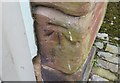
Ordnance Survey Cut Mark
This OS cut mark can be found on No76 High Street. It marks a point 20.102m above mean sea level.
Image: © Adrian Dust
Taken: 27 Mar 2018
0.01 miles
5
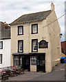
The White Star, Senhouse Street, Maryport
Image: © Alexander P Kapp
Taken: 5 Aug 2007
0.01 miles
6
The Middle Tap - Maryport - July 2016
Public house in Maryport.
Photograph is for record only - I have no connection with this business and cannot advise on its products or services.
Image: © The Carlisle Kid
Taken: 3 Jul 2016
0.02 miles
7
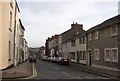
High Street, Maryport
Like Whitehaven, Maryport was set out in the 18C as a grid of streets, mostly lined with houses. This view is looking south from Wood Street.
Image: © Humphrey Bolton
Taken: 3 Jan 2004
0.02 miles
8
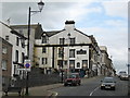
The Golden Lion Hotel, Maryport which has seen better days
Image: © Richard Rogerson
Taken: 15 Jul 2008
0.02 miles
9
Maryport Post Office
The contract documents in National Archives are dated 17 January 1914. The building was probably completed sometime in 1915, and opened a few months later after fitting-out. The architect was Charles Wilkinson of the Government's Office of Works department. He was also responsible for a large number of post offices in the North of England, including that of nearby Workington. Although it was often the practice to use local materials in the construction of such buildings, surprisingly brick was used for this building, despite the plethora of local stone. For more on the architecture of the British post office building visit this http://www.britishpostofficearchitects.weebly.com
Image: © Jim Osley
Taken: 28 Jun 2013
0.02 miles
10
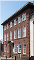
Maryport Post Office - June 2017
Situated on High Street and early 20th Century, a Post Office first appears on this site on the 1925 OS Map.
Image: © The Carlisle Kid
Taken: 19 Jun 2017
0.02 miles