IMAGES TAKEN NEAR TO
Nelson Street, MARYPORT, CA15 6BD
Introduction
This page details the photographs taken nearby to Nelson Street, CA15 6BD by members of the Geograph project.
The Geograph project started in 2005 with the aim of publishing, organising and preserving representative images for every square kilometre of Great Britain, Ireland and the Isle of Man.

There are currently over 7.5m images from over14,400 individuals and you can help contribute to the project by visiting https://www.geograph.org.uk
Image Map
Images are licensed for reuse under creativecommons.org/licenses/by-sa/2.0
Notes
- Clicking on the map will re-center to the selected point.
- The higher the marker number, the further away the image location is from the centre of the postcode.
Image Listing (213 Images Found)
Images are licensed for reuse under creativecommons.org/licenses/by-sa/2.0
Image
Details
Distance
1
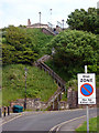
Maryport Town Steps
As painted by Lowry in 1954: http://www.lowry.co.uk/lowry-original-townstepsmaryport.html
Image: © John Lucas
Taken: 25 Jun 2013
0.03 miles
3
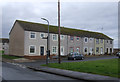
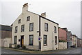
Site of "White Swan" pub, Nelson Street, Maryport - October 2017
Appearing on the 1866 OS Map, the "White Swan" was acquired by the State Management Scheme in November 1918. As it is not shown on the 1925 OS Map, it was probably instantly closed following purchase.
The building seen here was not part of the pub - OS Maps suggest the "White Swan" was situated within the fenced area now surrounding an electricity sub-station. Date of demolition has not been found, but seems to be post-1970.
Image: © The Carlisle Kid
Taken: 27 Oct 2017
0.04 miles
4
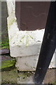
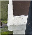
Benchmark on #2 Fleming Place
Ordnance Survey pivot benchmark described on the Bench Mark Database at http://www.bench-marks.org.uk/bm43791
Image: © Roger Templeman
Taken: 27 Jun 2012
0.06 miles
5
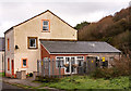
#2 Fleming Place
There is an OS benchmark Image on the ledge on the corner of the house to the right of the disc zone sign
Image: © Roger Templeman
Taken: 27 Jun 2012
0.06 miles
6
Ordnance Survey Pivot
This OS pivot can be found on the junction of High Street & Fleming Place. It marks a point 33.848m above mean sea level.
Image: © Adrian Dust
Taken: 27 Mar 2018
0.06 miles
7
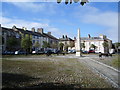
Fleming Square, Maryport
A path from each of the four corners converge on the obelisk, in this tree lined square.
Image: © Alexander P Kapp
Taken: 5 Aug 2007
0.07 miles
8

The Flimby Saxhorn Silver Band
Leading the parade at Maryport Community Carnival
Image: © Graham Hogg
Taken: 13 Jul 2019
0.07 miles
9
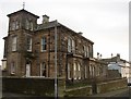
Solway House, Maryport
A higher-status house at the top (west) end of town and with a view over the sea.
Image: © Humphrey Bolton
Taken: 3 Jan 2004
0.07 miles
10
High Street, Maryport
This view is looking north from Wood Street.
Image: © Humphrey Bolton
Taken: 3 Jan 2004
0.07 miles