IMAGES TAKEN NEAR TO
Branthwaite, WORKINGTON, CA14 4TB
Introduction
This page details the photographs taken nearby to CA14 4TB by members of the Geograph project.
The Geograph project started in 2005 with the aim of publishing, organising and preserving representative images for every square kilometre of Great Britain, Ireland and the Isle of Man.

There are currently over 7.5m images from over14,400 individuals and you can help contribute to the project by visiting https://www.geograph.org.uk
Image Map
Images are licensed for reuse under creativecommons.org/licenses/by-sa/2.0
Notes
- Clicking on the map will re-center to the selected point.
- The higher the marker number, the further away the image location is from the centre of the postcode.
Image Listing (5 Images Found)
Images are licensed for reuse under creativecommons.org/licenses/by-sa/2.0
Image
Details
Distance
1
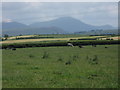
View towards Lakeland hills from Branthwaite
Image: © Alex McGregor
Taken: 22 Jun 2010
0.16 miles
3
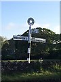
Direction Sign ? Signpost
Located on the north side of the T junction in Branthwaite, Dean parish. 3 arms and annulus finial. See also http://www.geog.port.ac.uk/webmap/thelakes/photos/bwa65.jpg.
Milestone Society National ID: CU_NY0524
Image: © H Stamper
Taken: 25 May 2020
0.18 miles
4
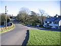
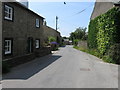
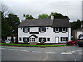
Road junction in Branthwaite.
One of the village pubs is showing in the background.
Image: © John Holmes
Taken: 18 Nov 2005
0.19 miles